Saturday, October 4, 2014

Big Basin Hike to Mount McAbee Overlook

Today was one of the hottest days of the year, but it didn't deter my De Anza College hiking class from a 5.5 mile trek through the Big Basin redwoods and on to the the overlook atop Mt. McAbee.

We started with a brief tour of the Big Basin Redwoods State Park park headquarters area, where we paused for a photo op at the "Auto Tree" (which doesn't allow autos inside the tree anymore), and then to the 1930's era visitors center, where we admired a large photo taken by park founder Andrew P. Hill.

Next, we toured the Redwood Loop Trail, which visits some of the most impressive trees in the park, including the Mother of the Forest and the Father of the Forest. We then left the city slickers behind as we crossed Opal Creek  and charged uphill on the Skyline to the Sea Trail. At the top of the first ridge we headed west on the Howard King Trail and then uphill on the Hihn Hammond Fire Road, which took us to our lunch stop at the Mount McAbee Overlook. Because there was no fog on the coast, we enjoyed spectacular views of Waddell Canyon and the Pacific Ocean. Because it was so hot we all found shady spots to sit while eating lunch.

After lunch we headed downhill on the Howard King Trail and the Hihn Hammond Road and then followed the Hihn Hammond Connector Trail back to the Skyline to the Sea Trail and on the the trail head.

TO GET THERE... From Skyline Boulevard take Highway 9 southwest and turn west on Highway 236 at Waterman Gap or at Boulder Creek.


Sunday, June 8, 2014

A Loop Through Portola State Park & Pescadero Creek County Park

Warm weather made yesterday a perfect day to wander among the shady redwoods of Portola State Park and Pescadero Creek County Park. This was my last College of San Mateo field trip for the season.

Meeting at the Ramada Group Day Use Area, we started off with an in-and-out on the Old Tree Trail to see some beautiful old growth redwoods, including an ancient fire-scarred giant that is one of the biggest in the park. After stopping at  the Shriners monument we then headed south on the Service Road, which crosses Pescadero Creek and intersects the Old Haul Road. We paused along the way at the pile of rotting boards that used to be the cabin of Christian Iverson, a former Pony Express rider who settled here in the 1860's.

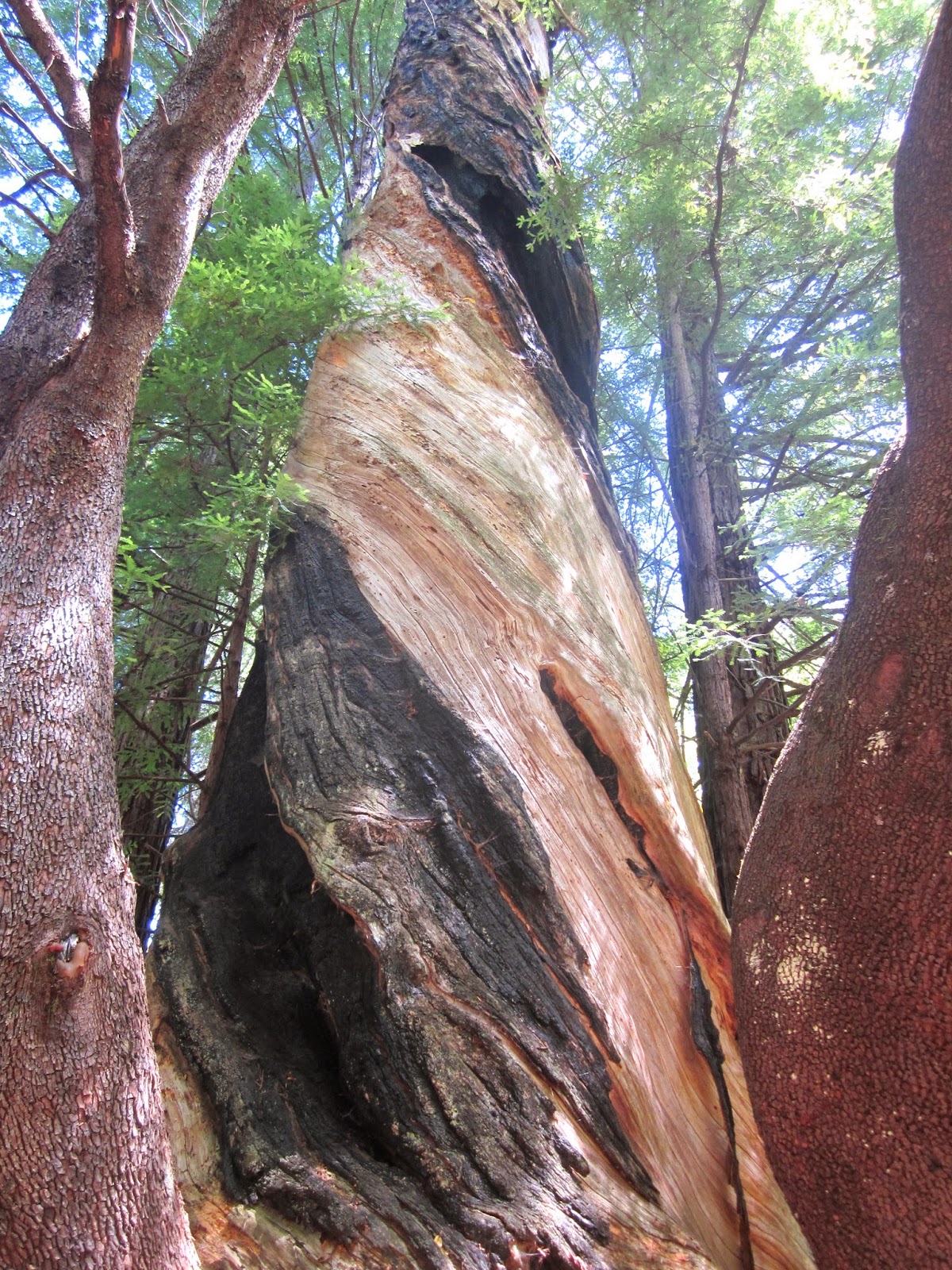
Just before reaching the Old Haul Road we entered Pescadero Creek County Park, which is the largest county park in San Mateo County.We continued northwest until we turned right onto another dirt road called Bridge Trail. Along the way to the creek we took a short side trip to view the Snag Tree, which is a large standing dead redwood with a distinctive light and dark spiral pattern. From there we headed on to Pescadero Creek for lunch. A beautiful seep monkey flower was in full bloom just across the creek.

After lunch we crossed the creek and stopped to appreciate the secluded campsites at the Tarwater Trail Camp. Each site is nestled among huckleberry bushes and towering redwoods. This is one of the few trail camps in the Santa Cruz Mountains that allows campfires.

From there we hiked the Pomponio Trail back to Portola State Park. Our total distance was about 5.75 miles. There is an entrance fee to park at Portola State Park.


TO GET THERE... Take Alpine Road west from Skyline Boulevard and turn south on Portola State Park Road..

Friday, May 30, 2014

A Fogless Hike up Montara Mountain

Last Saturday, May 24, I lead my College of San Mateo class up Montara Mountain on a day that was less than perfect for enjoying the spectacular views that stretch from the bay to the ocean, and many points north and south. It was mostly foggy, with occasional sun and a glimpse of Mount Diablo from the summit.

Conditions were very different on May 28 when I joined my Wednesday hiking group up the mountain. There was no fog and lots of sunshine all the way. Because of the moist maritime influence, there are still lots of wildflowers, including the beautiful native cobweb thistle.


I have included a few pictures just to give you an idea of what it was like.

Sunday, May 25, 2014

Fog and Sun on Montara Mountain

Montara Mountain rises out of the Pacific Ocean just above Devil's Slide south of Pacifica at the northern end of the Santa Cruz Mountains. It's steep granite peaks form an ecological island of biological diversity that includes plants found nowhere else. It is also a great place to see an amazing variety of wildflowers late in the season when inland areas have already entered the dry season.

The source of moisture on Montara Mountain is fog. Yesterday I lead my College of San Mateo class on a field trip through sun and fog to the summit of Montara's North Peak. Because of the fog, and despite the drought, the mountain is still lush green, with lots of wildflowers. Unfortunately, the fog prevented us from enjoying most of the spectacular views of the ocean, mountains, and bay that are one of the big attractions on a clear day.

Starting near the visitors center in San Pedro Valley County Park, we headed uphill on the Montara Mountain Trail and then walked the Montara Mountain Road to the 1,898 foot summit of North Peak.
Along the way we saw sweet peas, ferns, bright orange fungus on the eucalyptus, Douglas iris, yerba santa, morning glory, sticky monkey flower, Indian paintbrush, lizard tail, madrone, lots of manzanita, pitcher sage, blue blossom ceanothus, lupine, chinquapin, stonecrop, salal, red elderberry, blue elderberry, silk tassel, and many others.

As we ascended the mountain blue sky and fog took turns dominating the sky. Near the summit we burst into the sun, and at the top we could see an ocean of white all around. The fog, however, was so close to the summit, that the only Bay Area landmark we could see was Mount Diablo to the east. We then retraced our route on the Montara Mountain Road and Trail until we reached the intersection with the Brooks Creek Trail, which we followed to the Old Trout Farm Loop Trail. From there we headed back to the parking lot.


This is the longest and most strenuous hike I lead for my CSM and Foothill College classes. The total distance is about 7 miles, with a climb and descent of about 1,600 feet.

TO GET THERE... take Highway 1 to Pacifica and head southeast on Linda Mar Boulevard to Oddstad Boulevard. From there, drive into San Pedro County Park.


Saturday, May 17, 2014

El Corte de Madera Creek Open Space Preserve

I tried a new route today with my College of San Mateo class in Corte de Madera Creek Open Space. We met at Skeggs Point, as we have in the past; but then we carpooled south a couple of miles to the new parking lot along Skyline Boulevard near the south end of the preserve. This allowed us to walk one way for about 5.4 miles while visiting all the sights I wanted the class to see. Be aware that this preserve is very popular with mountain bikers. We had to step aside to let them pass a few times.


First we took the Sierra Morena Trail north to where it approaches Skyline Boulevard. We saw lots of banana slugs and some spotted coral root as we passed through a Douglas fir and second-growth redwood forest. We then crossed Skyline to visit the ancient old Methuselah Tree.

From there we hiked the Methuselah Trail to where it intersects the Manzanita Trail. (Un)fortunatlly I misinterpreted the map and guided our group the wrong way on the Manzanita Trail. The good part of this mistake is that we saw loads of chaparral pea in full bloom, magnificent manzanita loaded with berries, and golden chinquapins. After making our way back to the previous intersection, we sat on rocks for lunch and a tasty baynut brownie treat.

After lunch, we headed north on the Manzanita Trail and then east on the Fir Trail and on the Tafoni Trail to the turnoff for the Sandstone Formation. We viewed the amazing shapes and texture of the large sandstone outcropping. We also paused to admire some striped coral root, which is a saprophytic orchid. Then we walked south on the Fir Trail to the memorial to those who died on October 29, 1953 when a DC3 named Resolution crashed into the mountain nearby. From there we ascended to the Vista Point, though fog on the coast obscured much of our view. On the way we enjoyed the sight of many Douglas Iris and a few of the rare hairy star tulips.

From Vista Point we walked about 1.1 miles back to Skeggs Point via the Fir Trail. We stopped to look at a field of blooming flax and a dead Douglas fir that is used by a colony of acorn woodpeckers as a granary and nesting tree.

TO GET THERE...Skeggs Point is on the east side of Skyline Boulevard (Highway 35) about 4 miles north of Highway 84 and 1.5 miles south of Kings Mountain Road. There is a new parking lot a couple of miles to the south on the west side of Skyline Boulevard.

Saturday, May 10, 2014

A Clear And Sunny Day On Windy Hill

The fog dispersed, the clouds parted, and the sun shined on my College of San Mateo field trip today at Windy Hill Open Space Preserve.

The only way to see this preserve from top to bottom while keeping the hiking distance under six miles is to organize a car shuttle from the parking lot on Portola Road in Portola Valley to the preserve parking lot on Skyline Boulevard. We met at 10:00 AM at the parking lot in Portola Valley next to The Sequoias retirement home. We then carpooled to the northern most Windy Hill parking area along Skyline Boulevard. From there we took the Anniversary Trail, with side trips to the top of both Windy Hill summits. The views of the Pacific Ocean to the west and the cities and bay to the east were outstanding. What was even more amazing was that the wind hadn't come up yet.

We then took the Lost Trail south and then proceeded downhill and eastward on the Hamms Gulch Trail. Despite the drought there were lots of wild flowers in full bloom, especially poppies and columbine. We also enjoyed the sight of checkerbloom, blue-eyed grass, yarrow, oyster root, cow parsnip, Hookers fairy bells, toothwort, Ithureals spear, and a buckeye tree in bloom. We also enjoyed the sight of magnificent Douglas fir and white oaks. We saw a couple of blue-belly lizards and a garter snake on the way down.

The Spring Ridge Trail took us north and back to the parking lot. On the way we paused at Sausal Pond, which is a sag pond on the San Andreas Fault. Sag ponds form where a curve in the fault creates a gap which causes the land to sag and fill with water. In the pond we saw frogs,


fish and a couple of  pond turtles.

The total distance of our adventure was 5.2 miles, mostly downhill.

TO GET THERE... from Highway 280 take Alpine Road  and then go north on Portola Road, or take Sand Hill Road and go south on Portola Road.

Saturday, May 3, 2014

A Spring Excursion at Fall Creek

The Fall Creek unit of Henry Cowell Redwoods State park is a steep, forested, and magnificent 2,335-acre canyon, tucked into the rugged mountains northwest of Felton. Though this land is technically park of Henry Cowell, it is physically separated and has a different feel. It is much wilder, with no picnic tables, restrooms, campgrounds, or other amenities found in the southern unit of the park.

From the Felton Empire Road parking lot, my Foothill College class walked downhill on the Bennett Creek Trail to a trail junction with lots of thimble berry bushes. We then headed upstream on the Fall Creek Trail, pausing to enjoy the sight of Fall Creek as it tumbles over granite rocks. This is one of the most beautiful creeks in the Santa Cruz Mountains. We also stopped to examine second growth redwoods and how the forest has regenerated over the past century.

We then took the South Fork Trail up South Fall Creek to the lime kilns. Along the way we dipped our cups into a spring for a cold and delicious drink. In the 1870's this was California's biggest producer of lime, which is used to make cement. It continued producing until 1919. Near the powder magazine we left the trail briefly to watch goldfish swim around in a pool. From there we walked the Cape Horn Trail north to have lunch on the banks of Fall Creek.

After lunch, we headed upstream on the Fall Creek Trail to the Barrel Mill Site, where a water powered mill cut barrel staves to make barrels that was used to transport lime. We also sample baynut brownies. From there we hiked down stream on the Fall Creek Trail and then back up the Bennett Creek Trail to the parking lot. Our entire hike was a little over five miles.

TO GET THERE... From Highway 9 in Felton, the main parking lot is less than a mile northwest on Felton-Empire Road.