Friday, November 23, 2012

Pre-Thanksgiving hike at Windy Hill Open Space

November is one of my favorite months for hiking in the Santa Cruz Mountains. The rainy season has started and the plants are coming back to life. The banana slugs and newts are on the move. The forest is colored by madrone and toyon berries, and most of all by the brilliant yellows of the falling bigleaf maples leaves.

The Wednesday before Thanksgiving I built up my appetite with a 10.8-mile hike at Windy Hill Open Space Preserve with my Wednesday hiking group. This is a hike for people who want beautiful fall colors, great views from the ocean to the bay, and a serious aerobic workout. This route requires an elevation gain of more than 2,000 feet.


We started at the preserve parking lot off of Portola Road in Portola Valley, next to The Sequoias retirement home. We headed south, passing Sausal Pond, and continued on the Eagle Trail and then charged uphill on the Razorback Ridge Trail. We had to watch our step to avoid crushing migrating newts. The forest is lush and green, with lots of healthy sword ferns along the way. At the top of this trail we hiked north on the Lost Trail for lunch at the picnic tables at the Skyline Boulevard entrance to the preserve. You can cut eight tenths of a mile from the route by eliminating this part of the hike. We then headed downhill on the Hamms Gulch Trail. Be sure to pause to examine the magnificent weathered old Douglas fir trees near the top of the trail.

At the bottom of the hill we headed north on the Betsy Crowder Trail and back to where we started.

TO GET THERE... from Highway 280 take Alpine Road south to Portola Road in Portola Valley and turn right. The trail head is at the parking lot just north of The Sequoias retirement community.

Sunday, November 11, 2012

Long Ridge Open Space Loop

Yesterday was the final field trip for the fall session of my Foothill College hiking class. We met at the Grizzly Flat entrance to Long Ridge Open Space Preserve, which is along Skyline Boulevard about 3 miles south of the intersection with Page Mill/Alpine Road and about 3 miles north of the intersection with Highway 9. I arrived early and stood by the road so that the students would know where to park. The day was chilly but mostly sunny.

Our 4.9-mile loop took us downhill from Grizzly Flat, stopping to examine an abandoned apple orchard that was planted more than a hundred years ago. The trees still bear fruit, but they have all been picked by now. It is best to pick the fruit in early October. We then followed the Peters Creek Trail, which is on the bed of the old Summit Road. This route was constructed in the nineteenth century, long before Skyline Boulevard was built in the 1920's.

We next paused to enjoy a beautiful pond, which is just beyond the preserve boundary in the Jikoji Zen Center property. The pond was created in the early 1960's. This land hosted Pacific High School beginning in 1965. Students built their own residences, including tee pees and geodesic domes.

After a short stop to examine the pond, we charged uphill to the Long Ridge Road trail on the ridge top. We enjoyed beautiful views into the Pescadero Creek watershed and all the way to the blue Pacific beyond. Our group arrived at the Wallace Stegner Bench just in time for lunch. This is a very scenic spot for lunch. In addition to sweeping views, it is also a place to appreciate the contribution author and historian Wallace Stegner made to the preservation of wild lands. In addition to writing fiction and non-fiction about the American West, Stegner was an active conservationist, who was assistant to the secretary of interior during the Kennedy administration. He was instrumental in the formulation of the Wilderness Act of 1964. He also helped to found the Committee for Green Foothills, which lead to the creation of the Midpeninsula Regional Open Space District.

After lunch we sampled brownies made from the roasted nut of the bay laurel tree. We completed the loop by taking the Long Ridge Trail to the Peters Creek Trail and back to Grizzly Flat.


TO GET THERE... The Grizzly Flat parking lot is along Skyline Boulevard about 3 miles south of Page Mill/Alpine Road and 3 miles north of Highway 9. There is a small sign that says Upper Stevens Creek County Park. A Palo Alto City Limits sign faces north bound traffic on Skyline Boulevard.

Saturday, November 3, 2012

Pescadero Creek County Park Tarwater Trail Loop

You couldn't ask for a more beautiful day than today for a 5.6-mile hike through the shady second-growth redwood forest of Pescadero Creek County Park. Twenty-three students in my College of San Mateo class showed up for the adventure.

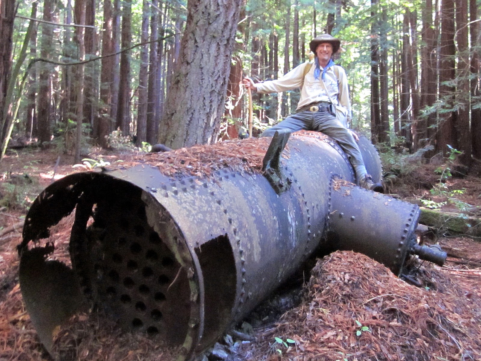
We met at the parking lot on Camp Pomponio Road. From there we headed downhill on the Tarwater Trail, pausing to examine a banana slug and a huge old-growth redwood with several substantial reiterations. It was spared the saw because one side is hollowed out by fire. Farther down the trail we stopped to check out the remains of the Moore, Fisher, & Troupe lumber mill, built in 1915. There is an old iron boiler used to power the one-piston steam engine that ran the circular saw.

From there we headed downhill to the Bridge Trail and proceeded south to check out the Tarwater Trail Camp and to pause for lunch on the south side of Pescadero Creek. After lunch we retraced our steps to the Tarwater Trail, pausing at the bridge over Tarwater Creek to read the sign warning that alcohol, firearms and illegal substances are not allowed in the County Jail, a short distance beyond. This jail, which housed Ken Kesey for marijuana possession during the 1960's, is now closed.

We charged uphill along Tarwater Creek on the Tarwater Trail, taking a short detour on the Canyon Trail to find out how the creek got its name. Some of the students stuck sticks into the gooey black tar that seeps into the creek. We then returned to Tarwater Trail and ascended the remainder of the route back to our starting point.

TO GET THERE... From Skyline Boulevard, take Alpine Road west, about half a mile past the turnoff to Portola State Park. Turn left at Camp Pomponio Road, which can be identified by 7 mailboxes and a sign that says:
"Men's Correctional Facility
Pescadero Creek County Park


7546"