Saturday, March 30, 2013

Big Basin Redwoods State Park hike to Mt. McAbee

My College of San Mateo Peninsula Parks & Trails class enjoyed sunny weather for a 5.75-mile ramble in Big Basin Redwoods State Park. Most of us met at Skylonda to carpool to Big Basin park headquarters.

We then toured the Redwood Loop Trail to see some of the most impressive old-growth redwoods in the Bay Area, including the Mother of the Forest, which may be the tallest tree in the Bay Area, and the Father of the Forest, which, as far as I know, is the biggest tree in the Bay Area. I showed a photo of park founder Andrew P. Hill standing next to this tree in 1904 and we noted a bench dedicated to his wife, Florence Watkins Hill (1858-1936).


We then crossed Opal Creek and followed the Skyline-to-the-Sea Trail west and uphill to the Middle Ridge Fire Road. From there we charged uphill on the Howard King Trail to the Hihn Hammond Road, which took us farther uphill to our lunch stop at the Mount McAbee Overlook, at 1,739 feet elevation.

Because rain was forecast later in the day, I feared that there wouldn't be much of a view from atop Mt. McAbee. Much to my relief, clear skies, sunshine, and a beautiful view of Waddell Canyon and Waddell Beach greeted us. After lunch we headed south and east on the Howard King Trail, where we saw a thriving forest of knobcone pines, a brilliant display of bush poppies, and some good views of Buzzard's Roost and Pine Mountain.

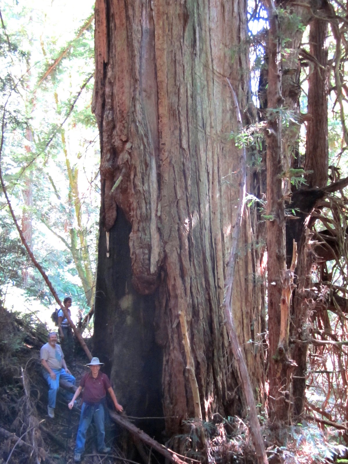
From there we headed downhill on the Hihn Hammond Road, took a look at a great swimming hole on Opal Creek, and then headed north on the Hihn Hammond Connector Trail and the Skyline-to-the-Sea Trail, which took us back to the parking lot.  From the parking lot, some of us visited a large burned-out redwood giant just north of the visitors center for a photo op.

TO GET THERE... From Skyline Boulevard take Highway 9 southwest and turn west on Highway 236 at Waterman Gap or at Boulder Creek.

Friday, November 23, 2012

Pre-Thanksgiving hike at Windy Hill Open Space

November is one of my favorite months for hiking in the Santa Cruz Mountains. The rainy season has started and the plants are coming back to life. The banana slugs and newts are on the move. The forest is colored by madrone and toyon berries, and most of all by the brilliant yellows of the falling bigleaf maples leaves.

The Wednesday before Thanksgiving I built up my appetite with a 10.8-mile hike at Windy Hill Open Space Preserve with my Wednesday hiking group. This is a hike for people who want beautiful fall colors, great views from the ocean to the bay, and a serious aerobic workout. This route requires an elevation gain of more than 2,000 feet.


We started at the preserve parking lot off of Portola Road in Portola Valley, next to The Sequoias retirement home. We headed south, passing Sausal Pond, and continued on the Eagle Trail and then charged uphill on the Razorback Ridge Trail. We had to watch our step to avoid crushing migrating newts. The forest is lush and green, with lots of healthy sword ferns along the way. At the top of this trail we hiked north on the Lost Trail for lunch at the picnic tables at the Skyline Boulevard entrance to the preserve. You can cut eight tenths of a mile from the route by eliminating this part of the hike. We then headed downhill on the Hamms Gulch Trail. Be sure to pause to examine the magnificent weathered old Douglas fir trees near the top of the trail.

At the bottom of the hill we headed north on the Betsy Crowder Trail and back to where we started.

TO GET THERE... from Highway 280 take Alpine Road south to Portola Road in Portola Valley and turn right. The trail head is at the parking lot just north of The Sequoias retirement community.

Sunday, November 11, 2012

Long Ridge Open Space Loop

Yesterday was the final field trip for the fall session of my Foothill College hiking class. We met at the Grizzly Flat entrance to Long Ridge Open Space Preserve, which is along Skyline Boulevard about 3 miles south of the intersection with Page Mill/Alpine Road and about 3 miles north of the intersection with Highway 9. I arrived early and stood by the road so that the students would know where to park. The day was chilly but mostly sunny.

Our 4.9-mile loop took us downhill from Grizzly Flat, stopping to examine an abandoned apple orchard that was planted more than a hundred years ago. The trees still bear fruit, but they have all been picked by now. It is best to pick the fruit in early October. We then followed the Peters Creek Trail, which is on the bed of the old Summit Road. This route was constructed in the nineteenth century, long before Skyline Boulevard was built in the 1920's.

We next paused to enjoy a beautiful pond, which is just beyond the preserve boundary in the Jikoji Zen Center property. The pond was created in the early 1960's. This land hosted Pacific High School beginning in 1965. Students built their own residences, including tee pees and geodesic domes.

After a short stop to examine the pond, we charged uphill to the Long Ridge Road trail on the ridge top. We enjoyed beautiful views into the Pescadero Creek watershed and all the way to the blue Pacific beyond. Our group arrived at the Wallace Stegner Bench just in time for lunch. This is a very scenic spot for lunch. In addition to sweeping views, it is also a place to appreciate the contribution author and historian Wallace Stegner made to the preservation of wild lands. In addition to writing fiction and non-fiction about the American West, Stegner was an active conservationist, who was assistant to the secretary of interior during the Kennedy administration. He was instrumental in the formulation of the Wilderness Act of 1964. He also helped to found the Committee for Green Foothills, which lead to the creation of the Midpeninsula Regional Open Space District.

After lunch we sampled brownies made from the roasted nut of the bay laurel tree. We completed the loop by taking the Long Ridge Trail to the Peters Creek Trail and back to Grizzly Flat.


TO GET THERE... The Grizzly Flat parking lot is along Skyline Boulevard about 3 miles south of Page Mill/Alpine Road and 3 miles north of Highway 9. There is a small sign that says Upper Stevens Creek County Park. A Palo Alto City Limits sign faces north bound traffic on Skyline Boulevard.

Saturday, November 3, 2012

Pescadero Creek County Park Tarwater Trail Loop

You couldn't ask for a more beautiful day than today for a 5.6-mile hike through the shady second-growth redwood forest of Pescadero Creek County Park. Twenty-three students in my College of San Mateo class showed up for the adventure.

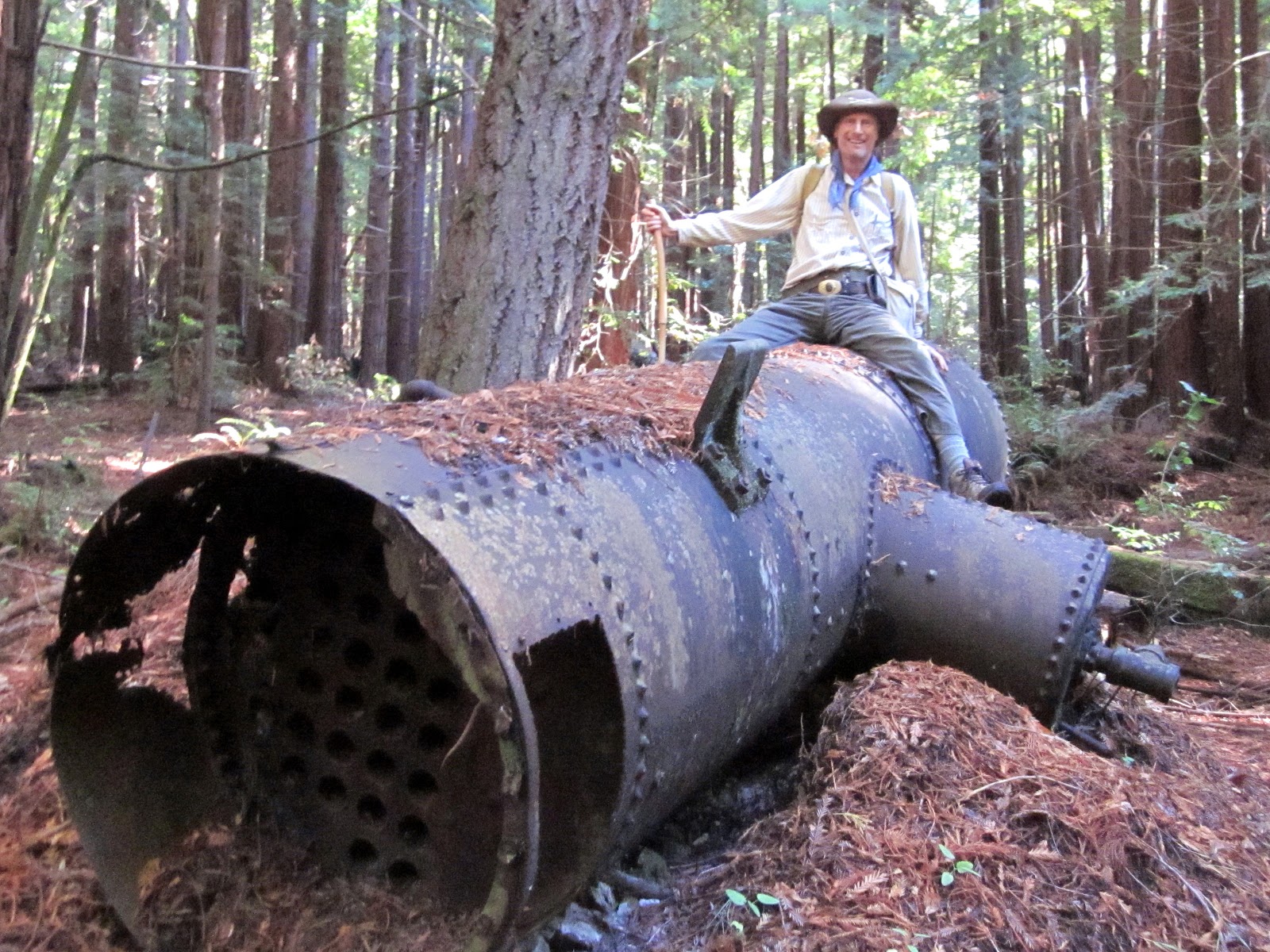
We met at the parking lot on Camp Pomponio Road. From there we headed downhill on the Tarwater Trail, pausing to examine a banana slug and a huge old-growth redwood with several substantial reiterations. It was spared the saw because one side is hollowed out by fire. Farther down the trail we stopped to check out the remains of the Moore, Fisher, & Troupe lumber mill, built in 1915. There is an old iron boiler used to power the one-piston steam engine that ran the circular saw.

From there we headed downhill to the Bridge Trail and proceeded south to check out the Tarwater Trail Camp and to pause for lunch on the south side of Pescadero Creek. After lunch we retraced our steps to the Tarwater Trail, pausing at the bridge over Tarwater Creek to read the sign warning that alcohol, firearms and illegal substances are not allowed in the County Jail, a short distance beyond. This jail, which housed Ken Kesey for marijuana possession during the 1960's, is now closed.

We charged uphill along Tarwater Creek on the Tarwater Trail, taking a short detour on the Canyon Trail to find out how the creek got its name. Some of the students stuck sticks into the gooey black tar that seeps into the creek. We then returned to Tarwater Trail and ascended the remainder of the route back to our starting point.

TO GET THERE... From Skyline Boulevard, take Alpine Road west, about half a mile past the turnoff to Portola State Park. Turn left at Camp Pomponio Road, which can be identified by 7 mailboxes and a sign that says:
"Men's Correctional Facility
Pescadero Creek County Park


7546"

Saturday, October 27, 2012

Henry Cowell State Park Redwood Ramble

Today I lead my Foothill College class on the same Henry Cowell Redwoods State Park route that I took my College of San Mateo class last Spring.  This is a wonderfully diverse 5.5-mile walk, which took us through a magical old-growth redwood grove, along the banks of the only real river in the Santa Cruz Mountains, to a sunny overlook with sandy soil, a unique ecology, and views of Monterey Bay.

We started at the parking lot near the park entrance, and continued on the Redwood Grove Loop Trail, stopping to admire some magnificent trees and to go inside the hollowed out John C. Fremont Tree, where Lieutenant Fremont is reputed to have camped in 1846.

We then proceeded south on the Pipeline Trail and uphill on the Eagle Creek Trail, stopping to admire a gnarly old-growth redwood which was spared the ax because of its gnarly condition. The trail then climbs above the redwoods and into the sand hills, which have a unique ecology all their own. Manzanita, knobcone pine, chinquapin, and ponderosa pine predominate in the sand hills. A right turn on the Pine Trail took us to the Overlook, where we stopped for lunch.


After lunch we headed downhill on the Ridge Fire Road and north on the Rincon Fire Road and the River Trail, which took us back to the Pipeline Trail. Just before returning to the Redwood Grove Loop Trail we stopped to examine a rare albino Redwood. This pure white phantom of the forest is a genetic mutant that lacks chlorophyll and is unable to photosynthesize. Because it cannot make its own food, it survives as a parasite by connecting its roots to a nearby redwood.

After returning to the parking lot, we crossed the railroad tracks and walked to the right to see a nineteenth century steam donkey and a steam-powered sawmill.

The big surprise is the entrance fee to the park. Since I was here last Spring the state has raised the entrance fee to $10.00 per car ($9.00 if you are over 62). It is still a bargain, especially if you carpool.


TO GET THERE... the main entrance is just south of Felton on Highway 9. The Rincon parking lot is 3.3 miles south of the main entrance on Highway 9.

Sunday, October 21, 2012

Skyline Ridge Open Space Figure-8 Ramble

Yesterday was a good day to lead my College of San Mateo class field trip at Skyline Ridge Open Space Preserve. The weather was sunny and mild, though the coastal fog to the west obscured some of the best views this preserve has to offer.

Starting at the main parking lot, which is just west of Skyline Boulevard about a mile south of the Page Mill/Alpine Road intersection, we charged uphill on the Ridge Trail and continued on, past Rattlesnake Point, to Alpine Pond. Near the pond we examined a bedrock mortar stone where Ohlone Indian women pounded their acorns centuries ago. We looped around the pond, looked at natural history exhibits at the David C. Daniels Nature Center next to the pond, and then stopped for lunch at the nearby picnic tables.

After lunch we visited the cluster of buildings that are now used for MPROSD maintenance. In the early 1930's this was the vacation retreat for California governor James "Sunny Jim" Rolph. Nearby is a dead Douglas fir tree which is home to a lively colony of acorn woodpeckers. They are now busy collecting acorns and fitting them into holes they made in their granary tree for later consumption.

We then made a steep ascent up the ridge and descended downhill to Horseshoe Lake. On the way we saw the feral Christmas trees that were not chosen decades ago when this land was a Christmas tree farm. Both Alpine Pond and Horseshoe Lake were created in the 1950's to provide water for John Rickey's hog farm. We then looped around the reservoir and back to our starting point, for a figure-8 loop of about 4.5 miles.


TO GET THERE... The main entrance is on Skyline Boulevard about a mile south of the intersection with Page Mill/Alpine Roads. There is one parking lot each for equestrians, handicapped, and all others. You can also access the preserve from the Russian Ridge Open Space Preserve parking lot on Alpine Road just west of its intersection with Skyline Boulevard. Take the trail through the tunnel under Alpine Road south from the parking lot.

Sunday, October 14, 2012

Purisima Creek Open Space Preserve

Yesterday was a gorgeous sunny day for a six mile field trip at Purisima Creek Open Space Preserve. This is a great destination for Summer and early Fall because fog drip keeps the forest moist and verdant all through the dry season.

My Foothill College class met at the main parking lot along Skyline Boulevard. We then carpooled about 3 miles south on Skyline Boulevard to a smaller parking area at the uphill end of the Purisima Creek Trail. Our one-way hike took us 1.6 miles down the Purisima Creek Trail, where we got a close look at some exceptionally large banana slugs. We then turned north on the Craig Britten Trail and followed it for 2.6 miles, stopping for lunch along the way. This stretch of trail offers a wide variety of scenery, from shady redwood canyons to sunny chaparral slopes with great views of the ocean.

We then turned right (uphill) on the Harkins Ridge Trail for a steep ascent and lots of beautiful views into the forested canyon and on to the blue Pacific. Some of the class walked off trail a couple of hundred feet to get a close look at the legendary Ohlone Whisper Tree, which is a large and gnarly old fire-scarred giant which was spared the ax long ago because of its wounds. Legend has it that if you approach this tree quietly and listen carefully, the tree will whisper to you the words you most need to hear.

Our group then headed to the North Ridge Trail and uphill to our original meeting place. The total distance of this hike is 6 miles.


TO GET THERE... The main entrance is on the west side of Skyline Boulevard about 4.5 miles south of Highway 92.