Saturday, October 30, 2010

Portola State Park Ramble


I conducted a tour of about 5 miles with my College of San Mateo class through a redwood forest at Portola State Park and adjoining Pescadero Creek County Park.
We met at the Ramada Day Use Picnic Area, which is beyond the visitors center, and then took a half mile side trip on the Old Tree Trail to the Old Tree. This tree is 12 feet in diameter and 297 feet tall. See attached photo. We then headed downhill on the Service Road to Pescadero Creek. After crossing the creek and checking out what little remains of the Iverson Cabin, we headed uphill to the Old Haul Road. There were so many newts roaming about that we had to watch every step in order to avoid crushing them.
We then walked west on the Old Haul Road and then north on Bridge Trail. We took a short side excursion on the Snag Trail to stop for lunch at the Snag Tree. This ancient dead redwood is twisted like a giant candy cane. See attached photo.
We then headed back to the Bridge Trail, crossed Pescadero Creek, and returned to Portola State Park via the Pomponio Trail.
To get to Portola State Park, take Alpine Road west from Skyline Boulevard and turn south on Portola State Park Road.

Saturday, October 23, 2010

The Wilder Side of Wilder Ranch


Rain didn't begin until the end of my Foothill/De Anza College field trip today at Wilder Ranch State Park. We met at the park headquarters and then carpooled a couple of miles west along Highway 1 to Four Mile Beach. Then we walked about 5-6 miles along the Ohlone Bluff Trail and Old Cove Landing Trail back to the park entrance. A car shuttle makes it possible to explore this spectacular stretch of rugged coast without retracing your steps.

After examining a wave-carved tunnel at Four Mile Beach we climbed up to the coastal bluffs and headed east and around Three Mile Beach. We skipped this beach because the trail access involves scrambling down some steep slopes. It seems counter-intuitive to describe this route as going eastbound. If you examine a map you will see that this park is on a part of the coast that goes east/west, not north/south. When you look out to sea you are actually looking south. On a clear day you can see the Santa Lucia Mountains south of Monterey.

We followed a trail down to Strawberry Beach for lunch. This is a very pleasant little beach, protected from the ocean breezes by cliffs. Because it is the most isolated of the beaches in this park, we had it all to ourselves. At Sand Point Beach we followed a narrow trail to the beach. One part of this route is a little precarious and requires careful footing. Just beyond this beach we saw five sea otters relaxing in the kelp. They were far enough away that binoculars were required to confirm their identity. A short distance farther we gazed down from the coastal bluff to a flat surf-pounded rock with dozens of relaxing harbor seals.

Fern Grotto Beach was our next stop as we entered an ancient sea cave adorned with hanging ferns. Upon ascending back to the bluffs we were treated to the sight of a sea otter swimming below us, close enough that binoculars were not needed.
The field trip was concluded with a visit to the historic ranch buildings, which were the center of the annual Harvest Festival activities. There was live music and demonstrations of nineteenth century technology and agricultural methods. My favorite is the workshop, which is powered by water via a pelton wheel. The shop comes alive with conveyor belts, which run a saw, drill, lathe and electric generator. This event is held every October.

Wilder Ranch State Park is along Highway 1 about 42 miles south of Half Moon Bay and 2 miles west of Santa Cruz.


Friday, October 8, 2010

Tarantulas are on the move


October is mating time for large harry terrestrial arachnids called tarantulas.
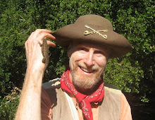
A good place to look for them is in oak woodlands and grasslands such as Monte Bello Open Space Preserve. Last Wednesday, along the Canyon Trail, a short distance south of the sag pond, my friend Don noticed one of these harry fellows along the trail. He picked up the spider and noticed that it was a male, probably on the prowl for a receptive female.

Tarantulas reside in silk-lined tubes in the ground. They ambush their prey, which usually consists of insects and other arthropods. They inject a venom to subdue their prey. The venom is not life threatening to humans.

There are hundreds of species of tarantulas in the world. This one reaches sexual maturity at seven years. Females lay 50 to 2,000 eggs.

Sunday, October 3, 2010

An Eventful Walk Along The San Andreas Fault


My October 2 College of San Mateo field trip to Monte Bello and Los Trancos Open Space Preserves did not exactly go as planned. On our way down the White Oak Trail, Lois seemed to be feeling faint and week from lack of water and sun exposure. After drinking water, she seemed to regain some strength. Several students hiked back up the trail to try to get a cell phone connection to call for help. I thought it would be better to continue downhill into the shade rather than to return uphill in the sun.

We waited at a trail junction that would allow easy access to Skyline Boulevard. Two MPROSD rangers arrived by foot via the White Oaks Trail, followed by a MPROSD truck coming down the trail from Skyline. Two Palo Alto fire fighters rode in the truck. When ranger Dennis Danielson requested that I stay behind, Liz offered to lead the field trip. The fire fighters evaluated Lois and determined that she should go to a hospital for further evaluation. Lois got in the truck along with her friend Anna. I will find out if Lois rode the awaiting ambulance to the hospital or if Anna drove her there.

I then rushed down the trail and soon caught up with the class. We looked at features of the San Andreas Fault and then crossed over Page Mill Road and on to the Fault Trail in Los Trancos Open Space Preserve. The entire route was about 4.5 miles.

I appreciate the assistance and patience of everyone on the field trip.

Sunday, July 11, 2010

The Bulls Are Back at Ano Nuevo


Many people assume that you have to visit Ano Nuevo State Reserve between December and March to see the elephant seals. That is the optimal time to see the giant pinnipeds mate and bear their young. However, some elephant seals are on the beaches all year.

This is the month to see the bull elephant seals come ashore to molt. Unlike other mammals, including humans, seals can't replace their fur and skin gradually through the year. To do that would compromise their insulation and risk hypothermia in the cold waters of the northern Pacific where they feed. Instead, they come ashore once a year to hang out at the beach and take it easy while their new skin grows back.

To see them in the summer you can walk out to the point on your own without a guide. Their will be docents on hand at the observation stations to explain what is going on. As you enter the reserve, you will be given a permit to go out beyond the staging area. Continue on the roped route to North Point, where most of the seals are hanging out. You will hear the cacophony of California sea lions and Northern fur seals on Ano Nuevo Island just offshore, and you can see them if you remembered to bring binoculars.
An extra treat is the bright yellow bush lupines in full bloom. You may be surprised by how many wildflowers are still in bloom.

TO GET THERE... Ano Nuevo State Reserve is on Highway 1 along the southern San Mateo County coast. The entrance is 23 miles south of Half Moon Bay and 19 miles north of Santa Cruz.

Saturday, June 26, 2010

A Summer Hike along Fall Creek


The Fall Creek Unit of Henry Cowell Redwoods State Park is the perfect place for a summer hike because it is forested, shady, and transected by a beautiful spring-fed creek that never lets up all through the dry season.

This 2,335-acre forested canyon, tucked into the rugged mountains northwest of Felton, is technically part Henry Cowell Redwoods State Park, though it is geographically separated from the more popular unit of the park south of Felton. The Fall Creek Unit has a much wilder feel, with no picnic tables, campgrounds, visitors centers, or entrance fee.

Fall Creek, issuing from countless springs, is one of the park's most wonderful features. It bounces wild and cold all summer, splashing over granite boulders which make it reminiscent of High Sierra streams. This granite was transported from hundreds of miles to the south by movement of the San Andreas Fault.

You will also encounter limestone, which was created from the shells of countless marine organisms and then uplifted from the ocean floor by the collision of tectonic plates. The South Fork Trail will take you to three granite lime kilns which were built in 1870 by the IXL Lime Company. Nearly all the redwoods in the canyon were cut to provide firewood for the kilns. When heated to 1700 degrees limestone loses its carbon dioxide to become a calcium oxide powder called lime, which is used to make cement.

For an ideal 3.5-mile loop from the Felton-Empire Road parking lot, walk downhill to the creek and then upstream on the North Fork Trail. Then turn left on the South Fork Tail to the lime kiln area. Then continue north on the Cape Horn Trail and follow the North Fork Trail downstream along Fall Creek and back to the parking lot. You can add another 1.6 miles to this route by continuing upstream along the North Fork Trail to the Barrel Mill Site, where you can see some equipment used to make barrel's for transporting the lime.

TO GET THERE... From Hwy 17 at Scotts Valley, take the Mount Hermon Road west toward Felton and turn right on Graham Hill Road. Proceed across Highway 9 in Felton, where it is called Felton Empire Road. Continue about a mile and look on your right for the Fall Creek Unit parking lot.

Saturday, May 29, 2010

A Perfect Day at Butano State Park


The weather was perfect for the final fieldtrip of the second session of my spring 2010 Peninsula Parks & Trail class, which was at Butano State Park. Because of recent rain, the park was moist, green and wildflowery.

We ascended Butano's south ridge by way of the Goat Hill and Doe Ridge Trails. On the way we saw several Spotted Coral Root orchids and many Clintonia in bloom. Upon reaching the Olmo Fire Road we headed east a short distance to a high point where we ate lunch and enjoyed sweeping views of the Butano Canyon to the north and the Gazos Creek Canyon to the south. From just the right spot you could see the ocean.

We then headed southwest on the Olmo Fire Trail and headed north (downhill) on the Goat Hill Trail, and on through the Ben Ried Campground, and back to our cars. There were lots of Douglas iris in bloom along the way. The campground was full, even though the cost of camping is now $35.00 per night.

The next session of my Peninsula Parks & Trails class starts on June 24. We will visit the Fall Creek unit of Henry Cowell Redwoods State Park, Ano Nuevo State Reserve, and Purisima Creek Open Space Preserve.