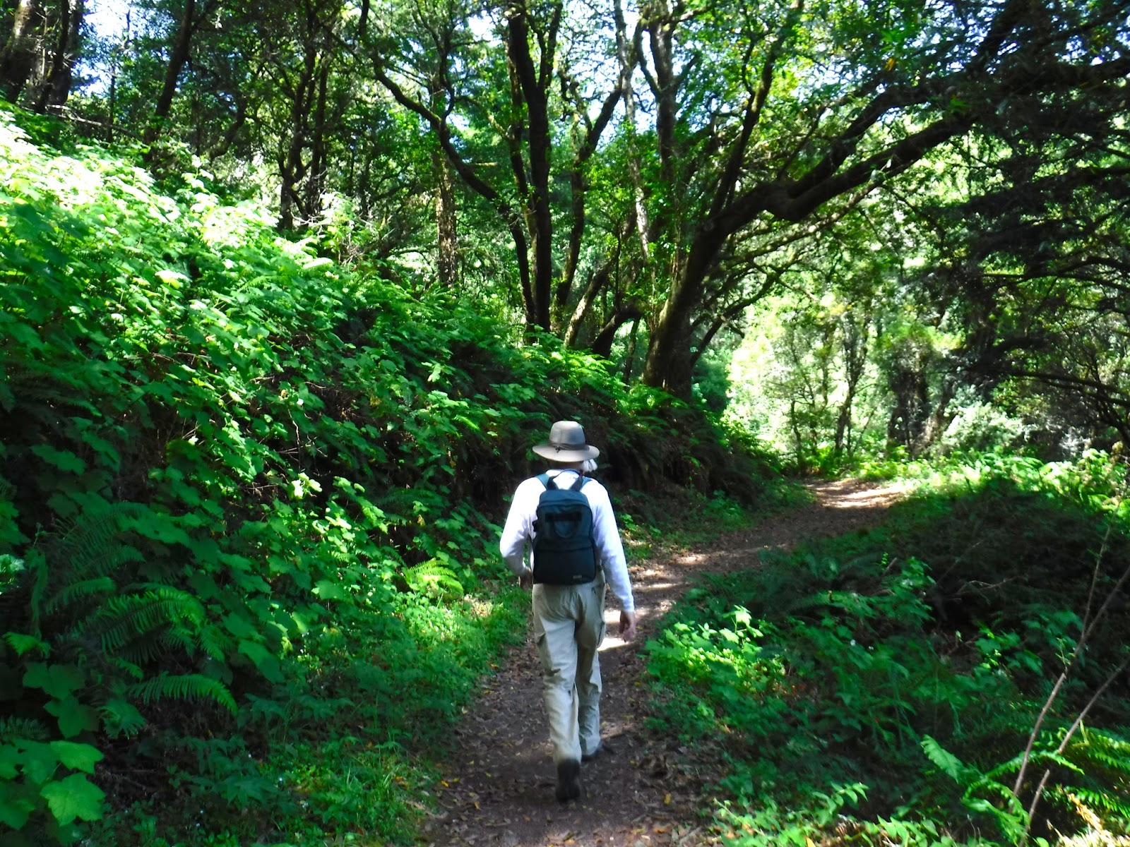
My De Anza College class lucked out with the weather yesterday. The first significant rain of the season fell on Friday. Saturday was comfortably drizzly; and then heavy rain fell again today. It is amazing how quickly the mostly second-growth redwood forest at Pescadero Creek County Park responded to rain in just one day.
This 6.5 mile hike is ideal for summer and fall, because it involves two bridge less crossings of Pescadero Creek, which could be impassable as the water rises with the winter storms. We started at the Hoffman Flat Trailhead on Wurr Road, which is off Pescadero Road between Pescadero Creek County Park and San Mateo County Memorial Park. Heading west on Pescadero Road it is easy to miss the Wurr Road turnoff. It is just beyond the Camp Loma Mar sign.
From the trail head we hiked .6 miles east on the Old Haul Road Trail. This route was constructed as a railroad bed in 1903 to haul redwood logs to a mill. In the 1950's the tracks were removed so it could be used by trucks. We saw two flocks of wild turkeys. From there we took the Pomponio Trail north for the first of our two creek crossings. Some of the students put on water shoes to wade across the creek. The rest of us walked carefully on rocks and a log without changing our shoes. Trekking poles are very helpful. Passing a grassy meadow called Worley Flat we continued east on the Pomponio Trail and then took the Parke Gulch Trail to pose inside a large old-growth redwood that was burned out by fire centuries ago. A short distance farther down the trail we stopped for lunch.
After lunch we got back on the Pomponio Trail, which passes through the Shaw Flat Trail Camp and then took the Shaw Flat Trail downhill to our second bridge less crossing of Pescadero Creek. After crossing the creek we headed uphill to connect with the Old Haul Road Trail, which took us west 1.8 miles back to where we began.
Though the rainy season only began one day before, the forest was moist and there were lots of banana slugs and mushrooms.
TO GET THERE... From Skyline Boulevard take La Honda Road west past the town of La Honda, turn left on Pescadero Road, and left on Wurr Road to the parking lot on the left side of the road.
Sunday, October 16, 2016
Saturday, October 8, 2016
A One Way Downhill Hike at Wunderlich County Park
My College of San Mateo class enjoyed a 5.6 mile one-way hike from Skyline Boulevard to Woodside Road in Wunderlich County Park in Woodside. We descended approximately 1,500 feet. This route will take you through the entire 940 acre park from top to bottom.
First, we met at the main parking lot on Woodside Road at 9:15 am. Because this is a very popular park on weekends it is advisable to arrive early. There is parking along Woodside Road if the parking lot is full.
We then carpooled about seven miles to a small parking area on the west side of the road near where Bear Gulch Road East intersects Skyline Boulevard. From there we carefully crossed Skyline and proceeded downhill on the Alambique Trail. We then turned north on the Bear Gulch Trail and paused for lunch at The Meadows. After lunch we continued down the Bear Gulch Trail and turned left on the Redwood Trail, which took us to a reservoir at Salamander Flat. This reservoir, which gets its water from Alambique Creek, was developed in 1904 to provide hydroelectric power for the Folger estate. There is so much duck weed covering the water that we couldn't see any newts.
From there we continued downhill on the Madrone Trail and turned right on the Bear Gulch Trail, which took us to the historic Folger stable (1905), which has been restored and contains a small museum. From there we car shuttled the drivers back to their cars at the starting point on Skyline Boulevard.
Along the way we saw red honeysuckle berries, yerba buena, rose hips, bay nuts, stinging nettle, second-growth redwoods, Douglas fir, and many other plants.
TO GET THERE... From Highway 280 take Woodside Road west and south. The
park entrance is about 2 miles beyond the town of Woodside.
First, we met at the main parking lot on Woodside Road at 9:15 am. Because this is a very popular park on weekends it is advisable to arrive early. There is parking along Woodside Road if the parking lot is full.
We then carpooled about seven miles to a small parking area on the west side of the road near where Bear Gulch Road East intersects Skyline Boulevard. From there we carefully crossed Skyline and proceeded downhill on the Alambique Trail. We then turned north on the Bear Gulch Trail and paused for lunch at The Meadows. After lunch we continued down the Bear Gulch Trail and turned left on the Redwood Trail, which took us to a reservoir at Salamander Flat. This reservoir, which gets its water from Alambique Creek, was developed in 1904 to provide hydroelectric power for the Folger estate. There is so much duck weed covering the water that we couldn't see any newts.
From there we continued downhill on the Madrone Trail and turned right on the Bear Gulch Trail, which took us to the historic Folger stable (1905), which has been restored and contains a small museum. From there we car shuttled the drivers back to their cars at the starting point on Skyline Boulevard.
Along the way we saw red honeysuckle berries, yerba buena, rose hips, bay nuts, stinging nettle, second-growth redwoods, Douglas fir, and many other plants.
TO GET THERE... From Highway 280 take Woodside Road west and south. The
park entrance is about 2 miles beyond the town of Woodside.
Saturday, October 1, 2016
A Fall Hike at Castle Rock State Park
Castle Rock State Park is so popular that on weekends you need to get there by 9:30 am at the latest to find a parking place. A ranger informed me that they will put a new 100 car parking lot at the new entrance, which will be at the Christmas tree farm just north of the current entrance. Hopefully it will still be possible to park along the road in order to avoid paying the parking fee.
I lead my De Anza College class on a delightful and adventurous 4.5 mile hike today. The sun was shining and the temperature was ideal. From the main entrance we hiked downhill through a forest on the Saratoga Gap Trail and then headed uphill on the Ridge Trail to Goat Rock. Using a thick rope, I helped most of the class up the backside of the rock to enjoy spectacular views of the San Lorenzo River Valley, Monterey Bay, and all the way south to the Santa Lucia Mountains. From there we took a short side trip to a hollowed out sandstone rock that is a perfect example of the process of cavernous weathering.
Continuing north and west on the Ridge Trail, we climbed into a cave at Hole-in-the-Wall Rock and then proceeded a short distance to our lunch stop at a magnificent canyon live oak. After lunch we took the Interconnector Trail to the Saratoga Gap Trail and then headed east to complete our loop. We enjoyed the sight of wild fuchsia in bloom. After briefly pausing at the little trickle of water that passes for Castle Rock Falls we hiked uphill to the intersection with the Castle Rock Trail. While waiting for everyone to catch up some of us watched a baby rattlesnake cross the trail.
Some of the students opted to take the short cut back to the parking lot. The rest of us charged uphill on the Castle Rock Trail to the namesake rock of the park. If you were going to make a fun rock to climb around on you couldn't design one better than Castle Rock. It has shallow caves, overhangs, cracks, ledges, and lots of stone appendages to make it interesting. Some of us climbed into a cave. From there we completed the route back to the parking lot.
TO GET THERE... Take Skyline Boulevard about 2.5 miles south from where it intersects Highway 9 (Saratoga Gap).
I lead my De Anza College class on a delightful and adventurous 4.5 mile hike today. The sun was shining and the temperature was ideal. From the main entrance we hiked downhill through a forest on the Saratoga Gap Trail and then headed uphill on the Ridge Trail to Goat Rock. Using a thick rope, I helped most of the class up the backside of the rock to enjoy spectacular views of the San Lorenzo River Valley, Monterey Bay, and all the way south to the Santa Lucia Mountains. From there we took a short side trip to a hollowed out sandstone rock that is a perfect example of the process of cavernous weathering.
Continuing north and west on the Ridge Trail, we climbed into a cave at Hole-in-the-Wall Rock and then proceeded a short distance to our lunch stop at a magnificent canyon live oak. After lunch we took the Interconnector Trail to the Saratoga Gap Trail and then headed east to complete our loop. We enjoyed the sight of wild fuchsia in bloom. After briefly pausing at the little trickle of water that passes for Castle Rock Falls we hiked uphill to the intersection with the Castle Rock Trail. While waiting for everyone to catch up some of us watched a baby rattlesnake cross the trail.
Some of the students opted to take the short cut back to the parking lot. The rest of us charged uphill on the Castle Rock Trail to the namesake rock of the park. If you were going to make a fun rock to climb around on you couldn't design one better than Castle Rock. It has shallow caves, overhangs, cracks, ledges, and lots of stone appendages to make it interesting. Some of us climbed into a cave. From there we completed the route back to the parking lot.
TO GET THERE... Take Skyline Boulevard about 2.5 miles south from where it intersects Highway 9 (Saratoga Gap).
Friday, August 12, 2016
A Loop Hike at Sanborn County Park
For many years I avoided Sanborn County Park because there were no good loop routes through this 3,449 acre steep forested park just east of Skyline Boulevard. Trail users like me
generally prefer traveling on loop trails instead of going in and out on the same route.
All that changed a couple of years ago when Santa Clara County Parks, along with trail volunteers, constructed the 3.4-mile John Nicholas Trail. This trail, which makes a precipitous drop from the Skyline Trail near Skyline Boulevard to the Lake Ranch Reservoir. With its many switchbacks, stone retaining walls, benches, and scenic overlooks, it is one of the best designed trails in the Santa Cruz Mountains. There is also a large sandstone outcrop along the way.
For an 8.4 mile hike with an elevation range of about 1,300 feet, start at one of the parking lots near the picnic area just beyond the park entrance. There is an entrance fee. Then proceed uphill on the Sanborn Trail and turn left (south) on the Skyline Trail. Then take a left (east) downhill on the John Nicholas Trail. Along the way are some benches with a spectacular view where you can pause for lunch. If you get there too early for lunch, continue downhill to the picnic tables under some exceptionally large big leaf maple trees beside the Lake Ranch Reservoir. Boating and swimming are not allowed in the reservoir. To make the hike longer you can explore the trail on the east side of the reservoir for an in and out walk.
From the reservoir, head downhill on the Lake Ranch Trail and then walk the Sanborn Road the rest of the way back to the park entrance.
TO GET THERE... From Saratoga, proceed two miles west on Highway 9, turn left onto Sanborn Road, and proceed one mile to the park entrance.
All that changed a couple of years ago when Santa Clara County Parks, along with trail volunteers, constructed the 3.4-mile John Nicholas Trail. This trail, which makes a precipitous drop from the Skyline Trail near Skyline Boulevard to the Lake Ranch Reservoir. With its many switchbacks, stone retaining walls, benches, and scenic overlooks, it is one of the best designed trails in the Santa Cruz Mountains. There is also a large sandstone outcrop along the way.
For an 8.4 mile hike with an elevation range of about 1,300 feet, start at one of the parking lots near the picnic area just beyond the park entrance. There is an entrance fee. Then proceed uphill on the Sanborn Trail and turn left (south) on the Skyline Trail. Then take a left (east) downhill on the John Nicholas Trail. Along the way are some benches with a spectacular view where you can pause for lunch. If you get there too early for lunch, continue downhill to the picnic tables under some exceptionally large big leaf maple trees beside the Lake Ranch Reservoir. Boating and swimming are not allowed in the reservoir. To make the hike longer you can explore the trail on the east side of the reservoir for an in and out walk.
From the reservoir, head downhill on the Lake Ranch Trail and then walk the Sanborn Road the rest of the way back to the park entrance.
TO GET THERE... From Saratoga, proceed two miles west on Highway 9, turn left onto Sanborn Road, and proceed one mile to the park entrance.
Thursday, July 14, 2016
Summer Hike to Berry Creek, Silver, & Golden Falls in Big Basin Redwoods State Park
I usually hike to the waterfalls on Berry Creek in late March or early April, when the volume of water pouring over the falls is at its greatest. This year I hiked this spectacular route in July instead. Though the water flow is diminished, the falls are still quite beautiful. Any time of year this is one of the best hikes in the Bay Area.
This 10.8 mile loop begins at the Big Basin State Park headquarters, where you pay your parking fee. Don't miss the easy Redwood Trail, which loops past some of the biggest Redwoods in the park, including The Father of the Forest tree. Then take the bridge across Opal Creek and follow the signs to the Skyline-to-the-Sea Trail. Follow this trail up the ridge and then down into the West Waddell Creek watershed, where you will enjoy the sight of many magnificent old-growth redwoods. From there, turn right (north) on the Berry Creek Falls Trail and head upstream a short distance to Berry Creek Falls.
Berry Creek Falls is 4.8 miles from the trailhead, and if you start
your hike about 10 am you should be there about lunch time. There is a wooden platform with benches overlooking the falls that is an ideal place to stop. After lunch, continue uphill, pausing to enjoy Silver Falls and Golden Falls. On a warm day it is good to pour some water over your head before the steep uphill ascent on the Sunset Trail. You will briefly climb above the redwoods onto a chaparral covered ridge top with views into the Berry Creek Canyon. From there, continue east on the Sunset Trail and then turn right on the Skyline-to-the-Sea Trail and then return to the trailhead.
TO GET THERE... From Skyline Boulevard take Highway 9 southwest and turn west on Highway 236 at Waterman Gap or at Boulder Creek. Be prepared for a long winding road.
This 10.8 mile loop begins at the Big Basin State Park headquarters, where you pay your parking fee. Don't miss the easy Redwood Trail, which loops past some of the biggest Redwoods in the park, including The Father of the Forest tree. Then take the bridge across Opal Creek and follow the signs to the Skyline-to-the-Sea Trail. Follow this trail up the ridge and then down into the West Waddell Creek watershed, where you will enjoy the sight of many magnificent old-growth redwoods. From there, turn right (north) on the Berry Creek Falls Trail and head upstream a short distance to Berry Creek Falls.
Berry Creek Falls is 4.8 miles from the trailhead, and if you start
your hike about 10 am you should be there about lunch time. There is a wooden platform with benches overlooking the falls that is an ideal place to stop. After lunch, continue uphill, pausing to enjoy Silver Falls and Golden Falls. On a warm day it is good to pour some water over your head before the steep uphill ascent on the Sunset Trail. You will briefly climb above the redwoods onto a chaparral covered ridge top with views into the Berry Creek Canyon. From there, continue east on the Sunset Trail and then turn right on the Skyline-to-the-Sea Trail and then return to the trailhead.
TO GET THERE... From Skyline Boulevard take Highway 9 southwest and turn west on Highway 236 at Waterman Gap or at Boulder Creek. Be prepared for a long winding road.
Wednesday, May 18, 2016
A Delightful 11 mile Hike on Windy Hill
If you are ready for an 11.2 mile hike with a climb and descent of about 1,800 feet then I can't think of a better place then Windy Hill Open Space Preserve. You can start this hike from either the Skyline Boulevard parking lot or the parking lot along Portola Road in Portola Valley. I like to start in Portola Valley because you get the uphill part of the loop out of the way first, before lunch.
From the Portola Valley entrance take the Spring Ridge Trail past Sausal Pond, which is a sag pond nestled into the San Andreas Fault. Then follow the Eagle Trail, which parallels Corte Madera Creek and turn right on the Razorback Ridge Trail. This is where you gain most of your altitude. At the top of the ridge turn right on the Lost Trail (which is also a segment of the Bay Area Ridge Trail), which will take you to the Skyline Boulevard entrance to the preserve. With several picnic tables, this is a great place to stop for lunch. After lunch, some of us continued north on the Anniversary Trail and ascended one of the two peaks of Windy Hill. The views here are spectacular. On a clear day you can see the bay and the ocean from the same place.
After lunch we retraced our steps on the Lost Trail and then headed downhill on the Hamms Gulch Trail. At the bottom we retraced the first part of the route to return to the parking lot. The ecological diversity of this preserve is amazing. It includes magnificent oaks near the bottom and douglas fir forests near the top. Because Windy Hill often lives up to its name, there are no trees near the summit, making it a great place to fly a kite. Though we are well into May, there are still lots of wild flowers, including columbine, clintonia, checker mallow, and poppies.
TO GET THERE... from Highway 280 exit Alpine Road in Portola Valley. Go south on Alpine Road about 2.9 miles to Portola Road. Turn right on Portola Road and travel .8 miles to the parking lot on the left side of the road.
From the Portola Valley entrance take the Spring Ridge Trail past Sausal Pond, which is a sag pond nestled into the San Andreas Fault. Then follow the Eagle Trail, which parallels Corte Madera Creek and turn right on the Razorback Ridge Trail. This is where you gain most of your altitude. At the top of the ridge turn right on the Lost Trail (which is also a segment of the Bay Area Ridge Trail), which will take you to the Skyline Boulevard entrance to the preserve. With several picnic tables, this is a great place to stop for lunch. After lunch, some of us continued north on the Anniversary Trail and ascended one of the two peaks of Windy Hill. The views here are spectacular. On a clear day you can see the bay and the ocean from the same place.
After lunch we retraced our steps on the Lost Trail and then headed downhill on the Hamms Gulch Trail. At the bottom we retraced the first part of the route to return to the parking lot. The ecological diversity of this preserve is amazing. It includes magnificent oaks near the bottom and douglas fir forests near the top. Because Windy Hill often lives up to its name, there are no trees near the summit, making it a great place to fly a kite. Though we are well into May, there are still lots of wild flowers, including columbine, clintonia, checker mallow, and poppies.
TO GET THERE... from Highway 280 exit Alpine Road in Portola Valley. Go south on Alpine Road about 2.9 miles to Portola Road. Turn right on Portola Road and travel .8 miles to the parking lot on the left side of the road.
Saturday, May 7, 2016
Redwoods to Sand Hills at Henry Cowell Redwoods State Park
Occasional showers didn't deter my College of San Mateo class from completing the final Spring 2016 field trip today at Henry Cowell Redwoods State Park. From the main parking lot off of Highway 9 south of Felton we hiked south on the western half of the Redwood Grove Loop Trail. We paused to admire magnificent old-growth redwoods, and some of us entered the interior of the Fremont Tree. After stopping to see an albino redwood we continued south on the Pipeline Road and then turned left (uphill) on the Eagle Creek Trail.
The Eagle Creek Trail climbs above the redwoods and into the realm of a unique ecosystem of sand hills. These hills are made of sand that was deposited deep in the ocean 15 million years ago and then uplifted to their present location near Felton and Scotts Valley. Because the sand is too porous to retain moisture it is unsuitable for redwood trees. Instead, it is inhabited by ponderosa pines and an assemblage of drought resistant plants, some of which only grow in this environment.
From the Eagle Creek Trail we turned right (south) on the Pine Trail to a large overlook structure where we stopped for lunch. From here we could see the surrounding mountains and south to Monterey Bay. We also enjoyed watching acorn woodpeckers coming and going from a nesting cavity in a dead
ponderosa pine (woodpecker photo by Diana Gustafson). We then headed downhill to the west on the Ridge Fire Road, which goes through a thriving community of native plants following a recent controlled burn.
Heading west on the Ridge Fire Road we rapidly descended back into the second-growth redwood forest and then turned right (north) on the Rincon Fire Road. We then continued north on the River Trail, which parallels the San Lorenzo River. From there we walked the eastern half of the Redwood Grove Loop Trail as it lead us back to the trail head.
On this field trip we saw banana slugs, wild ginger, redwood violet, manzanita, sticky monkey flower, yerba santa, bush poppy, lupine, wild rose, redwood sorrel, Douglas iris, thimbleberry, and many other wildflowers.
After the hike most of our class walked to the Roaring Camp & Big Trees railroad a short distance to the east, where we saw the remains of an old steam donkey and sawmill, and enjoyed the noisy and steamy appearance of the narrow-gauge steam engine.
TO GET THERE... the main entrance is just south of Felton on Highway 1.
The Eagle Creek Trail climbs above the redwoods and into the realm of a unique ecosystem of sand hills. These hills are made of sand that was deposited deep in the ocean 15 million years ago and then uplifted to their present location near Felton and Scotts Valley. Because the sand is too porous to retain moisture it is unsuitable for redwood trees. Instead, it is inhabited by ponderosa pines and an assemblage of drought resistant plants, some of which only grow in this environment.
From the Eagle Creek Trail we turned right (south) on the Pine Trail to a large overlook structure where we stopped for lunch. From here we could see the surrounding mountains and south to Monterey Bay. We also enjoyed watching acorn woodpeckers coming and going from a nesting cavity in a dead
ponderosa pine (woodpecker photo by Diana Gustafson). We then headed downhill to the west on the Ridge Fire Road, which goes through a thriving community of native plants following a recent controlled burn.
Heading west on the Ridge Fire Road we rapidly descended back into the second-growth redwood forest and then turned right (north) on the Rincon Fire Road. We then continued north on the River Trail, which parallels the San Lorenzo River. From there we walked the eastern half of the Redwood Grove Loop Trail as it lead us back to the trail head.
On this field trip we saw banana slugs, wild ginger, redwood violet, manzanita, sticky monkey flower, yerba santa, bush poppy, lupine, wild rose, redwood sorrel, Douglas iris, thimbleberry, and many other wildflowers.
After the hike most of our class walked to the Roaring Camp & Big Trees railroad a short distance to the east, where we saw the remains of an old steam donkey and sawmill, and enjoyed the noisy and steamy appearance of the narrow-gauge steam engine.
TO GET THERE... the main entrance is just south of Felton on Highway 1.
Subscribe to:
Posts (Atom)