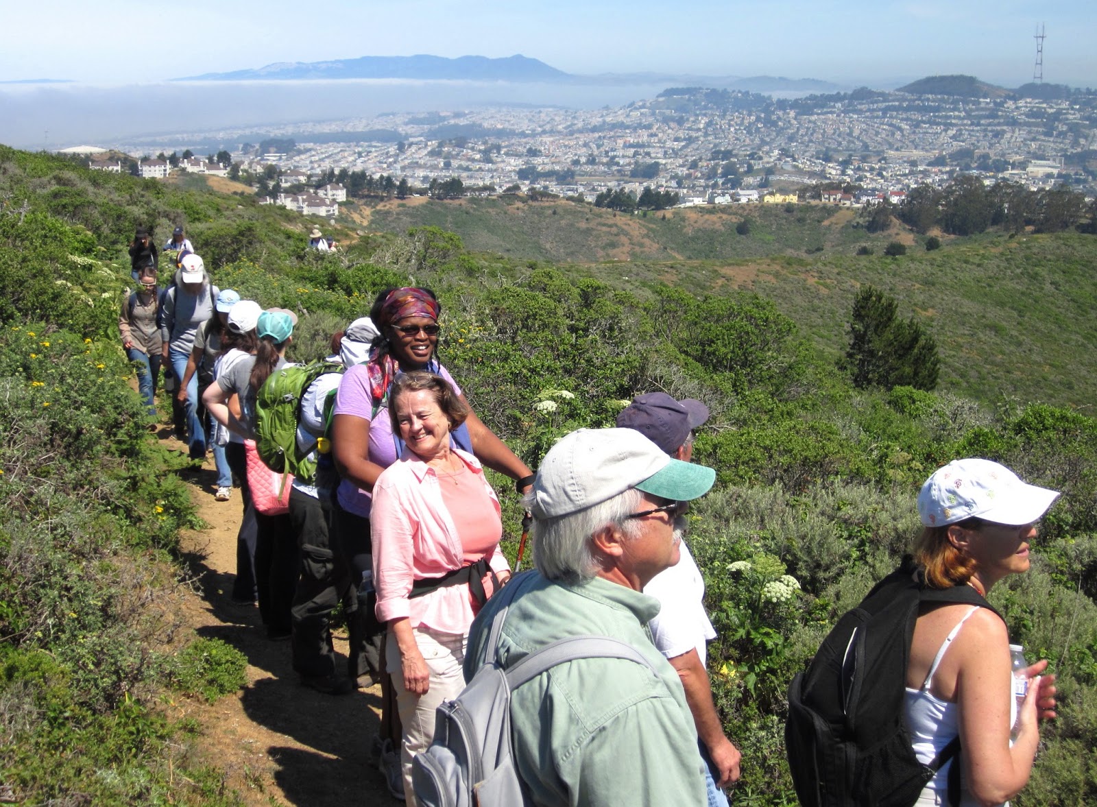
It was a beautiful sunny day for a 4.8-mile redwood ramble with my College of San Mateo class.
We met at the Woodside Town Hall parking lot to carpool to our destination. We noticed acorn woodpeckers inserting acorns into holes they made in a wooden building.
We started our hike from the Sam McDonald County Park parking lot on Pescadero Road. It is a big parking lot with a real restrooms. There is a $6.00 parking fee. We then crossed Pescadero Road and headed uphill on the Towne Trail. We took a short side excursion to see a huge old-growth redwood with reiterations that make it look like it has its arms in the air. I think I will call it the "Stick-Em-Up" tree.
The trail then abruptly climbs above the redwood forest into an oak woodland and grassland. We hiked past the horse camp and on to a ridgetop vista of the beautiful valley that holds Pescadero Creek and Pescadero Creek County Park. From there we visited the hikers hut which is owned and
operated by the Loma Prieta chapter of the Sierra Club.
From there it is all downhill to the Heritage Grove along Alpine Creek and Alpine Road. We examined beautiful old-growth redwoods and encountered a bridge over Alpine Creek that has been closed for repair for several years. I will call San Mateo County Parks to complain. However, we didn't let a little problem like that deter us from reaching the other side of the creek where there is a HUGE old-growth redwood and a great place for lunch. Because there is very little water in the creek this time of year, the crossing was not difficult. One of the students found a large banana slug which I put on a piece of plastic in order to show.
We then took the Heritage Grove Trail back to the parking lot, pausing on occasion to admire some more stately old redwood.
TO GET THERE...take La Honda Road and Pescadero Road west from La Honda.
Saturday, October 19, 2013
Sunday, October 13, 2013
Exploring the Rocks & Caves of Castle Rock State Park
Yesterday was a splendid sunny day for my Foothill College class to explore Castle Rock State Park. Carpooling from the Saratoga Library, we arrived just in time to grab the last few parking spaces along Skyline Boulevard. This park has become too popular on weekends for the limited parking now available. A new entrance with additional parking is planned.
From the main entrance we headed downhill on the Saratoga Gap Trail, pausing at a sandstone outcrop to examine the amazing process of "cavernous weathering", which only occurs in parts of the world with a Mediterranean climate. During the wet season, from November through April, rain water seeps into cracks in the rock. Then, during the long dry season, from May through October, the water, with dissolved calcium carbonate, is drawn to the surface to form a hard, erosion resistant, outer layer while the interior of the rock falls apart. That is why these rocks erode from the inside out, forming caves and interesting patterns called tafoni.
We then headed uphill on the Ridge Trail, bursting out of the woodland to reveal spectacular views of the San Lorenzo River Valley and on to the Pacific Ocean and Monterey Bay. After examining Goat Rock from the bottom, we ascended the trail to the uphill side, which can be ascended without technical aid. At least half the class made it to the top of Goat Rock, using various techniques, in order to enjoy the best view in the park. From there we stopped to look at what I call "Amphitheater Rock", which has lots of concretions called "cannonballs", and then headed on to a scenic overlook where we found an acorn woodpecker's granary tree stocked full of acorns for later consumption.
We left the Ridge Trail
to find Hole-in-the-Wall Rock, which has one of my favorite caves in the park. About half the class followed me to the top of the rock and then squeezed down a hole into a hollowed out chamber with a big picture window opening. It looks like a good place to live in case of nuclear war or the collapse of civilization. By then it was time for lunch at a huge canyon live oak with lots of seating in the form of rounded rocks and logs.
After lunch we took the first trail to the left, which connected us with the Saratoga Gap Trail. This trail has lots of sweeping vistas as it passes mostly through chaparral and occasional pockets of bay laurel. Some of the students saw a baby rattlesnake beside the trail. We stopped briefly to look at Castle Rock Falls, though it isn't much more than a trickle this time of year.
The grand finale was the ascent to the park's namesake, Castle Rock. Some of the students climbed into a shallow cave in the rock while the rest of the class circumnavigated the rock or watched rock climbers practice their sport. This rock is perfect fun for children and adults who never really grew up.
TO GET THERE... The main entrance is on the west side of Skyline Boulevard, about 2.5 miles south of its intersection with Highway 9 (Saratoga Gap).
From the main entrance we headed downhill on the Saratoga Gap Trail, pausing at a sandstone outcrop to examine the amazing process of "cavernous weathering", which only occurs in parts of the world with a Mediterranean climate. During the wet season, from November through April, rain water seeps into cracks in the rock. Then, during the long dry season, from May through October, the water, with dissolved calcium carbonate, is drawn to the surface to form a hard, erosion resistant, outer layer while the interior of the rock falls apart. That is why these rocks erode from the inside out, forming caves and interesting patterns called tafoni.
We then headed uphill on the Ridge Trail, bursting out of the woodland to reveal spectacular views of the San Lorenzo River Valley and on to the Pacific Ocean and Monterey Bay. After examining Goat Rock from the bottom, we ascended the trail to the uphill side, which can be ascended without technical aid. At least half the class made it to the top of Goat Rock, using various techniques, in order to enjoy the best view in the park. From there we stopped to look at what I call "Amphitheater Rock", which has lots of concretions called "cannonballs", and then headed on to a scenic overlook where we found an acorn woodpecker's granary tree stocked full of acorns for later consumption.
We left the Ridge Trail
to find Hole-in-the-Wall Rock, which has one of my favorite caves in the park. About half the class followed me to the top of the rock and then squeezed down a hole into a hollowed out chamber with a big picture window opening. It looks like a good place to live in case of nuclear war or the collapse of civilization. By then it was time for lunch at a huge canyon live oak with lots of seating in the form of rounded rocks and logs.
After lunch we took the first trail to the left, which connected us with the Saratoga Gap Trail. This trail has lots of sweeping vistas as it passes mostly through chaparral and occasional pockets of bay laurel. Some of the students saw a baby rattlesnake beside the trail. We stopped briefly to look at Castle Rock Falls, though it isn't much more than a trickle this time of year.
The grand finale was the ascent to the park's namesake, Castle Rock. Some of the students climbed into a shallow cave in the rock while the rest of the class circumnavigated the rock or watched rock climbers practice their sport. This rock is perfect fun for children and adults who never really grew up.
TO GET THERE... The main entrance is on the west side of Skyline Boulevard, about 2.5 miles south of its intersection with Highway 9 (Saratoga Gap).
Sunday, October 6, 2013
Purisima Creek Open Space Preserve
Yesterday was a spectacular clear day for a hike with my College of San Mateo class at Purisima Creek Open Space Preserve. We met at the main Skyline Boulevard parking lot, which is 4.5 miles south of Highway 92. We then carpooled 2 miles farther south to a small parking lot at the uphill end of the Purisima Creek Trail. That way we could walk one way for 5.8 miles. This 4,711-acre preserve is steep, scenic, and ecologically diverse. It is one of my favorites.
The first 1.8 miles is downhill into the second-growth redwood forest. We then turned right (north) on the Craig Britton Trail, pausing at the bridge over a small creek for lunch. This narrow trail, which is also part of the Bay Area Ridge Trail, snakes its way through the shady redwoods and then breaks into the sun and chaparral on the south facing slope of the ridge just north of Purisima Creek. There we got some great views and saw a woodrat nest.
At the north end of the Craig Britton Trail we turned right (east) on the Harkins Ridge Trail. This is by far the steepest part of our hike. Our efforts were rewarded, however, by a stunning view of mountains and ocean to the west
. It was clear enough to see Half Moon Bay and Pillar Point. The trail then enters the redwoods again, with a pause to take a quick look at the legendary Ohlone Whisper Tree.
The final part of the route offers a choice between the steep .3 mile road route and the .5 mile trail route that is less steep and more scenic. Most of us took the scenic route.
The first 1.8 miles is downhill into the second-growth redwood forest. We then turned right (north) on the Craig Britton Trail, pausing at the bridge over a small creek for lunch. This narrow trail, which is also part of the Bay Area Ridge Trail, snakes its way through the shady redwoods and then breaks into the sun and chaparral on the south facing slope of the ridge just north of Purisima Creek. There we got some great views and saw a woodrat nest.
At the north end of the Craig Britton Trail we turned right (east) on the Harkins Ridge Trail. This is by far the steepest part of our hike. Our efforts were rewarded, however, by a stunning view of mountains and ocean to the west
. It was clear enough to see Half Moon Bay and Pillar Point. The trail then enters the redwoods again, with a pause to take a quick look at the legendary Ohlone Whisper Tree.
The final part of the route offers a choice between the steep .3 mile road route and the .5 mile trail route that is less steep and more scenic. Most of us took the scenic route.
Sunday, July 21, 2013
A Spectacular Bloom Along Pescadero Creek
Spring is the big wildflower season in our area. However, there are some plants that choose to blossom in the other three seasons. A good example is the Tiger Lilly (Lilium pardalinum), which is in bloom now along creek banks in the Santa Cruz Mountains.
Also known as Leopard Lilly, it has
large showy orange flowers atop stems that can be three or more feet tall. I came across these where the Towne Fire Road crosses Pescadero Creek in Pescadero Creek County Park.
Also known as Leopard Lilly, it has
large showy orange flowers atop stems that can be three or more feet tall. I came across these where the Towne Fire Road crosses Pescadero Creek in Pescadero Creek County Park.
Saturday, June 8, 2013
Escaping the heat along shady Fall Creek
Today was the final field trip for the second Spring session of my College of San Mateo class. It was a warm day and a perfect day for a 5.1-mile exploration of the shady second-growth redwood forest in the Fall Creek Unit of Henry Cowelll Redwoods State Park. The main unit of this park is south of Felton. The Fall Creek unit is west of town via Felton Empire Road.
Starting at the parking lot about half a mile west of Highway 9, we headed downhill on the Bennett Creek Trail. We then sauntered north and along Fall Creek on the Fall Creek Trail. This creek is the main attraction of this park. Fed by hundreds of springs, it runs cold and pure all through the year as it bounces over granite rocks, resembling a creek that you might see in Yosemite. Along the way we paused to examine a banana slug.
We then turned left on the South Fork Trail, which follows the South Fork of Fall Creek to the lime kilns. Along the way we stopped to dip our cups into a pool of sparkling, pure, and cold limestone spring water. This water is as pure as it gets and loaded with healthy minerals, including calcium
We examined the lime kilns, which were built in 1872 by the IXL Lime Company. This area produced 50,000 barrels of lime per year during its heyday. That's nearly a third of all the lime produced in California at that time. Each barrel weighs 250 pounds. The limestone, which was quarried at nearby Blue Cliff, was heated in the kilns for three or four days to separate the carbon dioxide from the calcium carbonate in the rock. This made it turn into powder that could be loaded into barrels and then transported by wagon to Felton, and from there by railroad to awaiting ships in Santa Cruz. Lime is used to make cement.
Near the lime kilns we witnessed the mating of two banana slugs, walked a short distance off trail to see gold fish in small cistern, and saw the underground chamber where gunpowder was stored. Along the Cape Horn Trail we stopped to look at an inconspicuous spotted coral root orchid along the trail and a more flamboyant leafless wintergreen in full bloom. On the banks of Fall Creek we stopped for lunch and some of my baynut brownies before continuing upstream to the barrel mill, where a water-powered sawmill cut redwood lumber for the barrels used to transport the lime.
TO GET THERE... From Highway 9 in Felton, the main parking lot is about half a mile west on Felton Empire Road. Look for it on the right side of the road.
Starting at the parking lot about half a mile west of Highway 9, we headed downhill on the Bennett Creek Trail. We then sauntered north and along Fall Creek on the Fall Creek Trail. This creek is the main attraction of this park. Fed by hundreds of springs, it runs cold and pure all through the year as it bounces over granite rocks, resembling a creek that you might see in Yosemite. Along the way we paused to examine a banana slug.
We then turned left on the South Fork Trail, which follows the South Fork of Fall Creek to the lime kilns. Along the way we stopped to dip our cups into a pool of sparkling, pure, and cold limestone spring water. This water is as pure as it gets and loaded with healthy minerals, including calcium
We examined the lime kilns, which were built in 1872 by the IXL Lime Company. This area produced 50,000 barrels of lime per year during its heyday. That's nearly a third of all the lime produced in California at that time. Each barrel weighs 250 pounds. The limestone, which was quarried at nearby Blue Cliff, was heated in the kilns for three or four days to separate the carbon dioxide from the calcium carbonate in the rock. This made it turn into powder that could be loaded into barrels and then transported by wagon to Felton, and from there by railroad to awaiting ships in Santa Cruz. Lime is used to make cement.
Near the lime kilns we witnessed the mating of two banana slugs, walked a short distance off trail to see gold fish in small cistern, and saw the underground chamber where gunpowder was stored. Along the Cape Horn Trail we stopped to look at an inconspicuous spotted coral root orchid along the trail and a more flamboyant leafless wintergreen in full bloom. On the banks of Fall Creek we stopped for lunch and some of my baynut brownies before continuing upstream to the barrel mill, where a water-powered sawmill cut redwood lumber for the barrels used to transport the lime.
TO GET THERE... From Highway 9 in Felton, the main parking lot is about half a mile west on Felton Empire Road. Look for it on the right side of the road.
Saturday, May 25, 2013
A Walk On The San Andreas Fault
Today my College of San Mateo class took a 4.7-mile tour of the San Andreas Fault at Monte Bello Open Space Preserve and Los Trancos Open Space Preserve.
We assembled at the Monte Bello Open Space parking lot on Page Mill Road. We started by examining some conglomerate that was transported 23 miles over about 1.5 millions years of fault movement from the western flanks of Loma Prieta. We then hiked the White Oak Trail, which took us past some magnificent white, black, and live oaks and down to the Stevens Creek. We paused to enjoy the sight of mariposa lillies and globe lillies. On the way we witnessed the rough alligator lizard mating ritual. The male clamped his teeth onto the head of the female.
As we approached the Canyon Trail Liz Foreman saw something round and white in the forest duff next to the trail. At first I thought it was a mushroom; but when I picked it up we were surprised to find that is was a perfectly intact egg, without a crack in it. It was about 2.6 inches long, and it appeared to have been laid where we found it. If it had fallen out of a nest is would have broken. I have no idea what kind of bird egg this is.
After stopping for lunch, we headed north and uphill on the Canyon Trail, where we observed a pressure ridge on the San Andreas Fault and a sag pond where a bend in the fault caused the land to subside. We then crossed Page Mill Road and entered Los Trancos Open Space Preserve, where we followed the San Andreas Fault Trail for more evidence that we were walking on the interface between two massive continental plates. Posts mark the course of where the land ruptured during the 1906 earthquake. An offset fence provides evidence of fault displacement.
TO GET THERE... The main parking lot is on Page Mill Road about 7 miles west from Highway 280 and 1.4 miles east of Skyline Boulevard.
We assembled at the Monte Bello Open Space parking lot on Page Mill Road. We started by examining some conglomerate that was transported 23 miles over about 1.5 millions years of fault movement from the western flanks of Loma Prieta. We then hiked the White Oak Trail, which took us past some magnificent white, black, and live oaks and down to the Stevens Creek. We paused to enjoy the sight of mariposa lillies and globe lillies. On the way we witnessed the rough alligator lizard mating ritual. The male clamped his teeth onto the head of the female.
As we approached the Canyon Trail Liz Foreman saw something round and white in the forest duff next to the trail. At first I thought it was a mushroom; but when I picked it up we were surprised to find that is was a perfectly intact egg, without a crack in it. It was about 2.6 inches long, and it appeared to have been laid where we found it. If it had fallen out of a nest is would have broken. I have no idea what kind of bird egg this is.
After stopping for lunch, we headed north and uphill on the Canyon Trail, where we observed a pressure ridge on the San Andreas Fault and a sag pond where a bend in the fault caused the land to subside. We then crossed Page Mill Road and entered Los Trancos Open Space Preserve, where we followed the San Andreas Fault Trail for more evidence that we were walking on the interface between two massive continental plates. Posts mark the course of where the land ruptured during the 1906 earthquake. An offset fence provides evidence of fault displacement.
TO GET THERE... The main parking lot is on Page Mill Road about 7 miles west from Highway 280 and 1.4 miles east of Skyline Boulevard.
Saturday, May 11, 2013
A Sunny Spring Day on San Bruno Mountain
It would be hard to imagine a more perfect day to hike on San Bruno Mountain than I had today with my College of San Mateo Peninsula Parks & Trails class. The fog cleared before we commenced and the wind didn't pick up until we were nearly back to the parking lot. In between we enjoyed spectacular views, lots of wild flowers, and mild weather.
From the park & ride lot at the intersection of Bayshore Blvd. and Tunnel Road, we carpooled to the park entrance on Guadalupe Canyon Expressway and then proceeded to the trailhead parking lot. We then headed out counter-clockwise on the Summit Loop Trail, which is rather narrow and nearly overgrown in places with dense vegetation. Because of frequent fog, this park remains green, lush, and wildflowery long after more inland locations have entered their dry season dormancy.
Among the many wildflowers we enjoyed were buckwheat, iris, seaside daisies, asters, red and yellow Indian paintbrush, stonecrop, California perennial phacelia, checkerbloom, and wild onions. The biggest treat was the hummingbird sage, which was in full bloom and quite abundant. It is a native that is quite rare in other places.
We walked past the antennas on top of the mountain
and then stopped for lunch at an overlook with a panoramic view of the Bay Area. We then completed the loop by heading downhill on the Ridge Trail, Summit Loop Trail, Dairy Ravine Trail, and Eucalyptus Loop Trail.
TO GET THERE... From Highway 101 take the Bayshore Blvd. exit in Brisbane. Head north on Bayshore Blvd. and turn left (west) on Guadalupe Canyon Expressway to the park entrance.
From the park & ride lot at the intersection of Bayshore Blvd. and Tunnel Road, we carpooled to the park entrance on Guadalupe Canyon Expressway and then proceeded to the trailhead parking lot. We then headed out counter-clockwise on the Summit Loop Trail, which is rather narrow and nearly overgrown in places with dense vegetation. Because of frequent fog, this park remains green, lush, and wildflowery long after more inland locations have entered their dry season dormancy.
Among the many wildflowers we enjoyed were buckwheat, iris, seaside daisies, asters, red and yellow Indian paintbrush, stonecrop, California perennial phacelia, checkerbloom, and wild onions. The biggest treat was the hummingbird sage, which was in full bloom and quite abundant. It is a native that is quite rare in other places.
We walked past the antennas on top of the mountain
and then stopped for lunch at an overlook with a panoramic view of the Bay Area. We then completed the loop by heading downhill on the Ridge Trail, Summit Loop Trail, Dairy Ravine Trail, and Eucalyptus Loop Trail.
TO GET THERE... From Highway 101 take the Bayshore Blvd. exit in Brisbane. Head north on Bayshore Blvd. and turn left (west) on Guadalupe Canyon Expressway to the park entrance.
Subscribe to:
Posts (Atom)