Sunday, October 14, 2012

Purisima Creek Open Space Preserve

Yesterday was a gorgeous sunny day for a six mile field trip at Purisima Creek Open Space Preserve. This is a great destination for Summer and early Fall because fog drip keeps the forest moist and verdant all through the dry season.

My Foothill College class met at the main parking lot along Skyline Boulevard. We then carpooled about 3 miles south on Skyline Boulevard to a smaller parking area at the uphill end of the Purisima Creek Trail. Our one-way hike took us 1.6 miles down the Purisima Creek Trail, where we got a close look at some exceptionally large banana slugs. We then turned north on the Craig Britten Trail and followed it for 2.6 miles, stopping for lunch along the way. This stretch of trail offers a wide variety of scenery, from shady redwood canyons to sunny chaparral slopes with great views of the ocean.

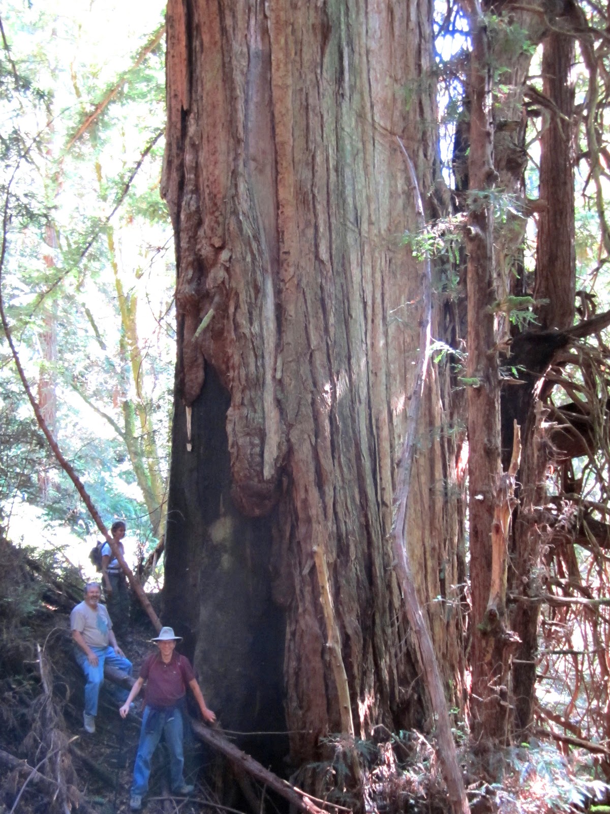
We then turned right (uphill) on the Harkins Ridge Trail for a steep ascent and lots of beautiful views into the forested canyon and on to the blue Pacific. Some of the class walked off trail a couple of hundred feet to get a close look at the legendary Ohlone Whisper Tree, which is a large and gnarly old fire-scarred giant which was spared the ax long ago because of its wounds. Legend has it that if you approach this tree quietly and listen carefully, the tree will whisper to you the words you most need to hear.

Our group then headed to the North Ridge Trail and uphill to our original meeting place. The total distance of this hike is 6 miles.



TO GET THERE... The main entrance is on the west side of Skyline Boulevard about 4.5 miles south of Highway 92. 

Sunday, October 7, 2012

A One-Way Ramble on Long Ridge

Here is a wonderfully diverse and scenic one-way 5-mile hike at Long Ridge Open Space Preserve. I tried out this route with my College of San Mateo class yesterday.

First, meet at the Grizzly Flat turnout, which is along Skyline Boulelvard, about 3.2 miles south of the intersection with Page Mill Road/Alpine Road. Leave some of the cars at Grizzly Flat and carpool about 3 miles south to the parking lot at Saratoga Gap (at the intersection of Skyline Boulevard and Highway 9). If the parking lot is full there is legal parking along the Highway 9 roadway west of the intersection.

Then cross Skyline and walk a short distance to the beginning of the Skyline-to-the-Sea/ Toll Road trail. Take the old nineteenth century toll road trail downhill (to the west) and turn right on the Skyline-to-the Sea Trail, which crosses Highway 9. On the other side of Highway 9 take the Achistaca Trail north for 1.7 miles in Long Ridge Open Space Preserve. This trail was named after a band of Ohlone Indians who once inhabited this area.

The Achistaca Trail takes you through shady stands of Douglas fir and bay trees, and into open grasslands and chaparral which offer sweeping views of the mountains all the way to the ocean. Continue north on the Hickory Oaks Trail, with a side trip to the left that takes you to Turtle Rock, at the highest point in the preserve. This is a great place for lunch, with wonderful views.


Continuing north, on the dirt road trail, take the narrow trail to the right, which connects with the Long Ridge Road Trail. Turn right (downhill) on the Peters Creek Trail to the edge of a beautiful pond, which is on the Jikoji Zen Buddhist property. Look for turtles in the pond. Continuing north on the Peters Creek Trail, you will pass an abandoned apple orchard on the right, which bears delicious fruit in the fall. Then head uphill to your awaiting car(s) at Grizzly Flat.

Saturday, June 9, 2012

San Mateo County Memorial Park

San Mateo County Memorial Park is a small redwood park with just enough trails for a 5-mile hike with my College of San Mateo class. The route we took offered views of old-growth redwoods, Pescadero Creek, and a ascent into a chaparral and oak woodland on a ridge top.

We met at the parking lot on Wurr Road, which is between San Mateo County Memorial and Pescadero Creek County Parks. We then walked down the road, across the creek to the trail into the park. At the Legion Flat Picnic Area we saw tables and stone fireplaces built by the WPA in the 1930's. Some of us entered a hollow redwood log which I used to play in when I was a kid. After checking out the old swimming hole, we examined the largest tree in the park before heading on to the amphitheater.

On our way through the Azalea Flat Campground we found some azaleas in bloom. After crossing Pescadero Road we headed up the Pomponio Trail. I found a couple of baby newts and an ensatina salamander under a log. We then ascended the Pomponio Trail for some good views of the Pescadero Creek watershed. The trail is quite overgrown in places and needs some work. After eating lunch along the Mt. Ellen Summit Trail, we headed downhill to the main entrance and back to our cars. On our way we walked through a hole in a large old-growth redwood.

The weather was perfect. A good place for a moderate hike.


TO GET THERE... From Skyline Boulevard, take La Honda Road west past La Honda and turn left on Pescadero Road. Follow Pescadero Road west and turn left on Wurr Road and continue to the parking lot on the left side of the road; or continue on Pescadero Road to the entrance to San Mateo County Memorial Park.

Saturday, May 26, 2012

A Foggy Day on Windy Hill

The weather did not cooperate today for my College of San Mateo field trip at Windy Hill Open Space Preserve. It was foggy and windy and fog condensation dripped from the Douglas fir trees as steady as if it were a rainy day. The spectacular views that normally greet hikers could only be conjured in our imaginations. On the bright side, there were lots of wildflowers, especially columbines, and the forest is still lush and green.

I had never lead a field trip at Windy Hill before because there are no loops that are under six miles. Plus, it is very steep terrain. To avoid that problem, we met at the preserve entrance on Portola Road in the town of Portola Valley. The parking lot is next to The Sequoias retirement home. We then carpooled to the northernmost Windy Hill Parking lot on Skyline Boulevard. We then started our five mile trek almost all downhill to the Portola Road parking lot. Our route followed the Anniversary Trail, Lost Trail, Hamms Gulch Trail, Meadow Trail, and the dirt road trail that goes to the east side of Sausal Pond. From start to finish we descended about 1,200 feet.

This turned out to be an outstanding route. It would be even better had the weather been more like it should be in late May instead of what you would expect in January.

Saturday, May 19, 2012

Castle Rock State Park

The weather was near perfect today when my College of San Mateo class explored Castle Rock State Park. It was such a great day that the parking lot filled up and there were only a few parking places left along Skyline Boulevard.

From the parking lot we headed west and downhill  and then uphill on the Ridge Trail to Goat Rock. After watching rock climbers from the bottom of the rock, we hiked up the trail to the backside of the rock, which is a much easier ascent. The more adventurous students scrambled to the top of Goat Rock for spectacular views of the San Lorenzo River Valley. We then headed down the trail and made a detour to Hole-in-the-Wall Rock. The truly adventurous among us climbed to the top of the rock and then lowered themselves down a small hole and into a cave in the middle of the rock. On our way to the lunch stop I caught a big alligator lizard.


After lunch we cut over to the Saratoga Gap Trail, which has lots of spectacular views. After pausing at Castle Rock Falls, we headed uphill and took a side trip to Castle Rock. The namesake feature of this park looks like it was designed for recreation. It has lots of caves and overhangs which make it a favorite with rock climbers. On the way to the rock we came across a display of a beautiful native orchid called spotted corral root.


TO GET THERE... The main entrance to Castle Rock State Park is along Skyline Boulevard about 2.5 miles south of its intersection with Highway 9.

Saturday, May 12, 2012

Springtime on Sweeney Ridge

Sweeney Ridge can be a risky place to conduct a field trip because it is often foggy and windy.

Today, however, was sunny and mild, and wildflowers were blooming in abundance. The second session of my CSM class met at the west end of Sneath Lane this morning. We then carpooled about 4 miles to parking lot F at Skyline College. The trail begins at parking lot C, but it is closed on weekends. Our one-way 3.75-mile hike began at Skyline College and took us along Sweeney Ridge to several Nike Missile radar stations left over from the Cold War era. We enjoyed lots of beautiful views of the ocean and the bay and many wildflowers, especially cow parsnip, blue blossom, checkerbloom, Douglas iris, hedge nettle, monkey flower, and Indian paintbrush, to name a few. The deep purple iris were the star of the show.

We stopped for lunch at the stone monument that marks the place where the Portola expedition first sighted San Francisco Bay on November 4, 1769. After lunch we headed downhill on the Sneath Lane trail, crossing the San Andreas Fault, and back to where we started.

TO GET THERE... from Highway 280 in San Bruno, take Sneath Lane west to where it ends at a locked gate. From Skyline Boulevard (Hwy 35) take College Drive west to Skyline College and park at parking lot C on weekdays or parking lot F on weekends. No parking permit is required on weekends.

Saturday, May 5, 2012

Skyline Ridge Open Space Preserve

It was a sunny and breezy day today for a 4.7-mile hike with my Foothill College class on Skyline Ridge Open Space Preserve. We met at the main parking lot on Skyline Boulevard and charged uphill on the Ipiwa Trail (Ridge Trail). Spectacular views of the Pescadero Creek watershed appeared as we reached the ridge summit. We then slowly descended to Alpine Pond, where we examined an ancient Ohlone Indian acorn pounding stone and watched a velvet ant cross the old Page Mill roadbed.

After crossing Alpine Road, we ventured up Russian Ridge for some good views. However, it was quite windy and the wildflower display on the ridge was less than would be expected for this time of year; probably the result of rain that was less than sufficient and too late. We then headed back to Alpine Pond where we found two vacant picnic tables just in time for lunch. Before resuming the hike we looked around in the Daniels Nature Center.

Our hike back took us along the Sunny Jim Trail around Horseshoe Lake, where we saw a pond turtle resting on a floating board.


TO GET THERE... the main entrance is on Skyline Boulevard about a mile south of the Page Mill Road/Alpine Road intersection.