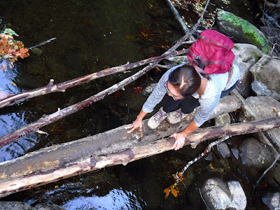
Here is a 6 mile loop through Pescadero Creek County Park that shouldn't be attempted during the rainy season when the water level in Pescadero Creek is high. In fact, even in October, when the creek flow is at its lowest there is the risk of wet feet during the two creek crossings.
Start at the Hoffman Flat Trailhead on Wurr Road, which is between San Mateo County Memorial Park and Pescadero Creek County Park. Take the Old Haul Road for .6 miles and then turn left (north) onto the Pomponio Trail to Worley Flat. This route involves a bridgeless crossing of the creek. You can either balance on a log connected to rocks, take off your shoes and socks and wade across the creek, or just charge through the water with your boots on. If you choose the first option a walking stick will come in handy.
This route passes a grassy meadow called Worley Flat, where a large dam was proposed in the 1960's. The Pomponio Trail continues on through oak woodlands and second growth redwoods as it crosses Jones Gulch and Towne Creek. You will probably see lots of banana slugs along the way. The Parke Gulch Trail is a .5 mile side trip that passes some impressive old-growth redwoods, especially one huge burnt-out redwood with a cavity big enough to hold at least 15 people. Just beyond is a good place to stop for lunch.
We then continued to the Shaw Flat Trail Camp, which has campsites with iron rings for campfires. There is even an outhouse. From there our plan was to take the Shaw Flat Trail downhill and across the creek in order to connect with the Old Haul Road. Our plans were scuttled by a sign warning that the trail ahead was dangerous due to damage from winter storms. As a result we returned to Shaw Flat and took the Towne Fire Road. This route crosses the creek at a wide spot, where the creek is shallow. About half of the class carefully stepped from rock to rock in order to avoid getting wet feet. The other half just said the hell with it and charged through to the other side. From there it was a 1.4 mile walk back to the parking lot via the Old Haul Road.
TO GET THERE... From La Honda take Highway 84 south and turn left onto Pes
cadero Road and turn left on Wurr Road. If you reach the entrance to San Mateo County Memorial Park you have gone too far.
Sunday, October 29, 2017
Saturday, October 21, 2017
A Loop Hike through Portola Redwoods State Park & Pescadero Creek County Park
Today was a beautiful day for a 6 mile redwood loop through Portola Redwoods State Park & adjacent Pescadero Creek County Park.
My De Anza College class carpooled from the Saratoga Library parking lot to the Ramada Group Day Use Area in Portola Redwoods State Park. Just before reaching our starting point we stopped at the park headquarters to pay the entrance fee. We started our hike by taking the Old Tree Trail to view one of the biggest and oldest redwoods in the park. We paused to examine one of many banana slugs we encountered due to the rain last Thursday night. After returning to the Ramada Day Use Area we began our loop hike by heading south on
the Service Road to where it intersects the Old Haul Road, which marks the boundary between Portola State Park and Pescadero Creek County Park.
We then headed west on the Old Haul Road, which was the route of a narrow-gauge railroad that transported redwood logs to the many sawmills in the area in the late nineteenth and early twentieth centuries. We then turned right onto the Bridge Trail, which heads north toward Pescadero Creek. Along the way we encountered a newt that was crossing the road. Before reaching Pescadero Creek we walked a few hundred feet up the Snag Trail to see a giant dead redwood with unusual black & white spiral stripes. We then continued to our lunch stop along Pescadero Creek.
After lunch we headed north on the Bridge Trail and then right (east) on the Pomponio Trail, which returned us to Portola State Park and our cars.
TO GET THERE... From Skyline Boulevard take Alpine Road west and then turn south on Portola State Park Road.
Tuesday, October 17, 2017
A (nearly smokeless) Hike at Purisima Creek Redwoods Open Space Preserve
I was concerned about going ahead with the scheduled field trip for my College of San Mateo class last Saturday, October 14. The problem was that smoke had been drifting south from the big wild fires in Napa and Sonoma Counties, resulting in unhealthy air quality. I arrived early at the main Purisima Creek Redwoods Open Space parking lot on Skyline Boulevard with no idea how many, if any, of my 30 students would actually show up.
Fourteen students arrived, and because the sky was blue and there was only the slightest hint of smoke in the air they all wanted to do the entire 6 mile hike. From the main parking lot we carpooled about 2 miles south to the small parking area at the uphill end of the Purisima Creek Trail. This turnout can be hard to identify because there is no sign along the road to tell you that this is a trail head. If there isn't parking in the lot you can park along Skyline Boulevard nearby. Just make sure you are not parked on the wrong side of the white line.
I like to do this car shuttle route because it offers a good and scenic hike without the necessity of descending all the way to the bottom of the ridge before climbing back up to Skyline. This route took us downhill on the Purisima Creek Trail to the where we headed
north on the Craig Britton Trail, which is also part of the Bay Area Ridge Trail. We stopped for lunch at a bridge over a creek. We then turned right at the Harkins Ridge Trail and ascended the steepest part of the route to a scenic overlook with spectacular views of the Pacific Ocean and coast north of Half Moon Bay. On the way back we stopped for a glimpse of the legendary "Ohlone Whisper Tree", which is said to whisper to you the words you most need to hear. Much to our delight there were even some asters in bloom nearby.
TO GET THERE... The main entrance is on Skyline Boulevard about 4.5 miles south of where it intersects Highway 92.
Subscribe to:
Comments (Atom)


